Missouri v. Iowa
The ruling resolved a long-standing border dispute between the two states, which had nearly erupted in military clashes during the so-called "Honey War" of 1839.
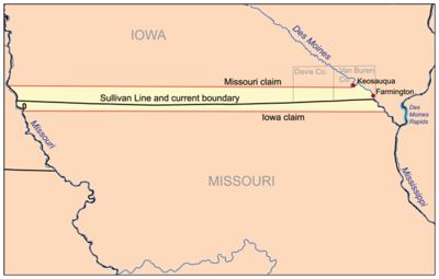
[3] However, although the treaty specified a boundary which ran due east, the Sullivan Line tended north slightly and was irregular rather than straight.
[5] After another series of intense congressional debates and parliamentary maneuvers, Congress passed legislation approving Missouri's statehood on February 28, 1821, and the President of the United States signed the bill on March 2.
Brown found a set of small rapids near present-day Keosauqua, Iowa, and ran the border due west from that point.
[10] In 1838, the Missouri Legislature passed a law declaring this line its northern boundary, essentially seizing nearly 2,600 square miles (6,700 km2) of land from the Iowa Territory.
[17] He noted that the federal government had signed more than 15 treaties with various Indian tribes, all of which recognized the Sullivan Line as the northern border of Missouri.
[20] Third, Catron noted that the United States had respected the Sullivan Line in establishing the borders of the various territories north of Missouri.
With almost no discussion, he concluded: "This Court is, then, driven to that call in the Constitution of Missouri which declares that her western boundary shall correspond with the Indian boundary line, and treating the western line of a hundred miles long as a unit and then running east from its northern terminus, it will supply the deficiency of a call for an object that never existed.
[25] In an extensive decree, the Court described the Sullivan Line, ordered a commission (composed of a surveyor from Iowa and a surveyor from Missouri) to survey and mark the line, and empowered Chief Justice Taney to enforce the decree or appoint commissioners (in the event of death, disability, or refusal to act).