Ledo Road
[6] In the 19th century, British railway builders had surveyed the Pangsau Pass, which is 1,136 metres (3,727 feet) high on the India-Burma border, on the Patkai crest, above Nampong, Arunachal Pradesh and Ledo, Tinsukia (part of Assam).
After Rangoon was captured by the Japanese and before the Ledo Road was finished, the majority of supplies to the Chinese had to be delivered via airlift over the eastern end of the Himalayan Mountains known as the Hump.
[8] General Claire Lee Chennault, the USAAF Fourteenth Air Force commander, thought the projected tonnage levels were overly optimistic and doubted that such an extended network of trails through difficult jungle could ever match the amount of supplies that could be delivered with modern cargo transport aircraft.
[9] The road was built by 15,000 American soldiers (60 percent of whom were African-Americans) and 35,000 local workers at an estimated cost of US$150 million (or $2 billion 2017).
Major General Wheeler, in turn, assigned responsibility of base commander for the road construction to Colonel John C. Arrowsmith.
Steep gradients, hairpin curves and sheer drops of 60 m (200 ft), all surrounded by a thick rain forest was the norm for this first section.
The building of this section allowed much-needed supplies to flow to the troops engaged in attacking the Japanese 18th Division, which was defending the northern area of Burma with their strongest forces around the towns of Kamaing, Mogaung, and Myitkyina.
Before the Ledo road reached Shingbwiyang, Allied troops (the majority of whom were American-trained Chinese divisions of the X Force) had been totally dependent on supplies flown in over the Patkai Range.
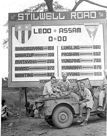
To get to the Mong-Yu junction the Ledo Road had to span 10 major rivers and 155 secondary streams, averaging one bridge every 4.5 km (2.8 mi).
On 12 January 1945, the first convoy of 113 vehicles, led by General Pick, departed from Ledo; they reached Kunming, China on 4 February 1945.
The capture of the Myitkyina airstrip enabled the Air Transport Command "to fly a more southerly route without fear of Japanese fighters, thus shortening and flattening the Hump trip with astonishing results.
[9][14] By the time supplies were flowing over the Ledo Road in large quantities, operations in other theaters had shaped the course of the war against Japan.
"[17] The units initially assigned to the initial section were:[18] In 1943 they were joined by: From the middle of April until the middle of May 1944 Company A of the 879th Airborne Engineer Battalion worked 24 hours a day on the Ledo Road, construction of their base camp and Shingbwiyang airfield, before deploying to Myitkyina to improve the facilities of an old British airfield recently recaptured from the Japanese.
In January 1945, four of the black EABs (along with three white battalions) continued working on the now renamed Stilwell Road, improving and widening it.
I believed that, properly equipped and efficiently led, Chinese troops could defeat Japanese if, as would be the case with his Ledo force, they had a considerable numerical superiority.
The book First Overland written about this expedition by Tim Slessor (1957) reported that bridges were down in the section between Pangsau Pass and Shingbwiyang.
In February 1958 the Expedition of Eric Edis and his team also used the road from Ledo to Myitkyina en route to Rangoon, Singapore and Australia.
In his book about this expedition The Impossible Takes a Little Longer, Edis (2008) reports that they have removed a yellow sign with India/Burma on it from the Indian/Burmese border and that they have donated it to the Imperial War Museum in London.
These groups successfully travelled the road but none made any comment on the political or human rights situation on Burma afterward.
In India, there is Stilwell park in Lekhapani near Ledo to mark the beginning of the Stilwell road, a World War 2-era cemetery between Jairampur and Pangsau Pass for the Chinese soldiers and labourers who built the road, a still existing bridge near Nampong nicknamed "Hell's Gate" due to treacherous conditions and landslides in the area.
[27] A post went viral in Philippines in 2019 which showed the current picture of 24-zigzag hairpin turns of Stilwell road on a mountain slope in Qinglong County in Guizhou province of China.
[29] In 2015, the section from Namyun to Pangsau Pass in Burma was a "heavily rutted muddy track" through the jungle according to a BBC correspondent.