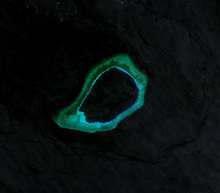
Subi Reef
[2][3][4][5] On 12 July 2016, the UNCLOS special arbitral tribunal in the Philippines v. China case confirmed that Subi Reef is, or in its natural condition was, exposed at low tide and submerged at high tide and is, accordingly a low-tide elevation that does not generate entitlement to a territorial sea, exclusive economic zone or continental shelf, but is within 12 miles of a high-tide feature Sandy Cay on the atoll's west of Thitu Island.
[7] The PRC has ratified UNCLOS III;[7] the convention establishes general obligations for safeguarding the marine environment and protecting freedom of scientific research on the high seas, and also creates an innovative legal regime for controlling mineral resource exploitation in deep seabed areas beyond national jurisdiction, through an International Seabed Authority and the Common heritage of mankind principle.
[8] The atoll is controlled by China (PRC), with a 2014 estimate of 200 troops stationed there,[9] and also claimed by Taiwan (ROC), Vietnam and the Philippines.
[11] Also in 2015, the USS Lassen sailed within 12 nautical miles (which if applicable is the territorial waters limit of the atoll), prompting the Chinese Foreign Ministry to call the action a "provocation" and vowed to keep building up in the South China Sea.
[12][13] During 2014, the PRC started reclaiming land at Subi Reef, and by the end of 2015 had developed it into an island of 3.95 square kilometres (1.53 sq mi), with a military base, a large harbor, and an airstrip of about 3,000 metres (9,800 ft).