Suburbs of Dunedin
At the end of Lower Stuart Street, 400 metres from the Octagon, lie Anzac Square and the Dunedin Railway Station, with an industrial area and the harbour beyond.
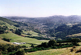
The main inner suburbs, clockwise from due north of the city centre, include the following: Pine Hill is a southern spur of Mount Cargill, the 660-metre volcanic outcrop that dominates the northern end of Dunedin's urban area and is topped by the city's main television transmitter tower.
The Northern Motorway, part of State Highway 1 winds north around the hill's western flank.
Pine Hill's 2001 population was 2,259, including the older suburb of Dalmore to the south and the post-war state housing development of Liberton.
The city's main indoor sporting arena, Forsyth Barr Stadium is also located in Dunedin North, immediately to the southeast of Logan Park.
Lindsay Creek, a tributary of the Water of Leith, flows southwest down the long North East Valley at the northern end of Dunedin's urban area.
The original North East Valley post office was located near the foot of Baldwin Street, but was relocated to the Gardens to be nearer the retail area.
Normanby is the name of the northern end of North East Valley, at which point Dunedin's urban area gives way to open countryside.
The slopes of Mount Cargill itself are densely wooded, and are crisscrossed with walking tracks, some of which start at the Bethune's Gully reserve, at the northern end of Normanby.
Mount Mera is an area of state housing sitting on the north facing side of the valley, just above Normanby.
Opoho suburb sits on the western flank of Signal Hill overlooking North East Valley and the Dunedin Botanic Gardens.
It is a residential suburb with very mixed demographics, containing student flats, significant numbers of elderly citizens, and the houses of many in the academic community.
Above the suburb sits the Centennial Lookout, a memorial built on the top of Signal Hill to mark the centenary of New Zealand in 1940.
The suburb of Ravensbourne sits on the southern slopes of Signal Hill, close to the edge of the Otago Harbour.
The area was the site of coastal defences during World War II, and the remains of lookouts from the era can be found on a hill above the suburb.
A major sports facility, The Edgar Centre, is located close to the harbour foreshore just to the north of Andersons Bay Inlet.
At the northeastern edge of the suburb, closest to the city centre, is the small residential area of Kensington.
At the southern end of the suburb lies Forbury Park, the city's main horse racing (trotting and pacing) venue.
St Kilda has three pubs, a bowling green, a badminton hall as well as an Olympic-sized ice-skating rink.
Five kilometres southwest of the city centre, St Clair lies on the lower slopes and at the foot of Forbury Hill.
Lower down the hill to the east, close to Caversham and Forbury, lies the smaller but more prosperous suburb of Kew.
There is farmland on its south-western border, whilst the direct neighbour suburbs are Caversham, Corstophine, Concord and Lookout Point.
This end of the suburb is dominated by one of Dunedin's largest industrial sites, the Hillside Railway Workshops.
At the western end of the suburb, the valley rises steeply, culminating in a saddle of the motorway at Lookout Point.
Due west of the city centre, with primary access up High Street, sits the hill suburb of Mornington.
Numerous popular walking tracks traverse the bush-clad reserve land surrounding this reservoir.
The main outer suburbs, clockwise from the city centre (starting due north), include the following: Beyond Ravensbourne on the main road to the mouth of the Otago Harbour and the town of Port Chalmers lie the two small settlements of Maia and Burkes (or Burkes Bay).
On the west bank of the Otago Harbour beyond Burkes, equidistant between Ravensbourne and Port Chalmers, lies the sleepy residential settlement of St Leonards.

1- George St
2- The Octagon
3- Moray Place
4- Princes St (numbered at The Exchange )
5- Upper Stuart St
6- Lower Stuart St
The black line is the railway, the blue lines are State Highway 1 (northbound to the left, southbound to the right).