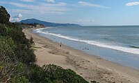
Summerland, California
Summerland is a census designated place (CDP) in Santa Barbara County, California.
Tar from natural oil seeps in the Summerland area was used for sealing their ocean-going tomols by the Chumash people and for the Mission Santa Barbara as waterproofing for the roof.
In 1888 he divided his land tract, on a moderately sloping hill facing the ocean, into numerous parcels.
He promoted the tiny lots – 25 x 60 – to fellow Spiritualists, who bought them in quantity and moved to the area.
The spiritual center of the town was a Spiritualist Church, with séance room, demolished when Highway 101 was put through in the 1950s.
Numerous wooden oil derricks were built on the beach, and on piers stretching into the ocean.
[7] Peak production from the onshore portion of the Summerland Field did not occur until 1930; the last oil was pumped from the nearshore region in 1940.
[9] In January 1969, a blowout at the Dos Cuadras Field, about five miles offshore, caused the Santa Barbara Oil Spill, a formative event for the modern environmental movement.
[10] In August 2015, Summerland's beach was closed for several days by County of Santa Barbara health officials due to large amounts of oil washed onshore.
[11] Local residents suspect the petroleum source is a leaking capped oil well ("the Becker wellhead") in the tidal area below Lookout Park.
[13] It is on the coast directly east at Ortega Ridge Road at the unincorporated community of Montecito and west-northwest of the city of Carpinteria.
This region experiences warm (but not hot) and dry summers, with no average monthly temperatures above 71.6 °F.