U.S. Route 26 in Oregon
The highway heads east from there through the Oregon Coast Range, providing access to Saddle Mountain and passing through the valleys of the Necanicum and Nehalem rivers.
It then crosses over the Oregon Coast Range, where it passes through the Dennis L. Edwards Tunnel, descending into the Tualatin Valley, into the community of Banks.
[1] East of Banks, the highway merges with Oregon Route 6 (OR 6) and becomes a freeway, which passes through the high-tech regions of Washington County.
Also at this point, MAX Light Rail is adjacent on the north side of the highway for nearly two miles (3.2 km) until it submerges into the Robertson Tunnel.
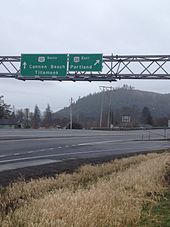
The highway skirts the southern edge of Portland's Washington Park, providing access to the Oregon Zoo and other attractions.
Obsidian, bear grass, and slaves were transported over these trails to major trading locations along the Columbia River in exchange for dried salmon, smelt, sturgeon, and decorative sea shells.
Captain John C. Frémont followed this route on his 1843 explorations for the U.S. and Lieutenant Henry Larcom Abbot headed a Pacific Railroad survey party along it in 1855.
[3] Both the Works Progress Administration[4] and Civilian Conservation Corps participated in the construction during the Great Depression.
[8][9] The state and county government later considered moving US 26 to Division Street between I-205 and Gresham to improve freeway access.
[10] The cancelled freeway included plans to bypass Sandy, which were later revived in the 2000s and 2010s to address congestion issues in the area.
[citation needed] In 2020, US 26 was designated POW/MIA Memorial Highway by the state legislature following a request from the Bend Heroes Foundation and Oregon Veterans Motorcycle Association.