Superior, Montana
[6] The post office was established in 1871 after Mineral County became the site of one of the largest gold strikes that helped settle the West.
Mining has remained central to the economy, along with the development of logging and United States Forest Service activities.
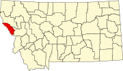
[7] Superior is located on the northeast side of the Bitterroot Range of mountains in western Montana.
The Clark Fork flows through downtown, heading northwest towards St. Regis and ultimately emptying into Lake Pend Oreille near Cabinet, Idaho.
Nearby Lookout Pass Ski and Recreation Area receives approximately 400 in (1,000 cm) of snow each winter.
The snow pack melts throughout the spring and summer months, feeding the many mountain streams and creeks with water.
All the water eventually reaches the Clark Fork in the valley below, where Superior is located.
37.6% of all households were made up of individuals, and 17.8% had someone living alone who was 65 years of age or older.
33.8% of all households were made up of individuals, and 12.8% had someone living alone who was 65 years of age or older.
The Superior School District educates students from kindergarten to 12th grade.
[12] The Mineral County Public Library is located in Superior.
