Surface Water and Ocean Topography
While past satellite missions like the Jason series altimeters (TOPEX/Poseidon, Jason-1, Jason-2, Jason-3) have provided variation in river and lake water surface elevations at select locations, SWOT will provide the first truly global observations of changing water levels, stream slopes, and inundation extents in rivers, lakes, and floodplains.
SWOT brings together the hydrology and oceanography communities and will extend the precise, high-resolution surface topography observations into the coastal and estuarine regions.
), biodiversity, health (preventing the propagation of water-borne diseases), the agricultural sector, energy (including the management of electricity production and offshore gas and oil rigs), territorial development; all these areas and more stand to benefit from this new satellite mission.
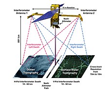
[citation needed] The satellite will fly two radar antennas at either end of a 10 m (33 ft) mast, allowing it to measure the elevation of the surface across a 120 km (75 mi) wide swath.
[13] SWOT was developed by an international group of hydrologists and oceanographers to provide a better understanding of the world's oceans and its terrestrial surface waters.
[14] It will give scientists their first comprehensive view of Earth's freshwater bodies from space and much more detailed measurements of the ocean surface than ever before.
[3] The mating of the payload made by Jet Propulsion Laboratory (JPL) took place on 11 August 2021 at Thales Alenia Space Cannes Center, France.