Sutherland
There are four national scenic areas wholly or partly in the county: Assynt-Coigach, North West Sutherland, Kyle of Tongue and Dornoch Firth, with the first three of these lying along the western and northern coasts.
It is possible that Sigurd may have taken Ross to the south as well, but by the time of his death in 892 the southern limit of his territory appears to have been the River Oykel.
The bishop's seat was initially at Halkirk, but in the early 13th century was moved to Dornoch Cathedral, which was begun in 1224.
In 1667 Commissioners of Supply were established for each shire, which would serve as the main administrative body for the area until the creation of county councils in 1890.
Although they shared a sheriff after 1748, Caithness and Sutherland remained legally separate counties, having their own commissioners of supply and, from 1794, their own lord lieutenants.
The Sutherland Estate (consisting of about two thirds of the county) had the largest scale clearances that occurred in the Highlands, much of this being carried out in 1812, 1814 and 1819–20.
[18] One effect of the clearances was that it concentrated Gaelic speakers in the newly created fishing villages, so extending the survival of the language in these communities.
Work by the linguist Nancy Dorian from the 1960s onwards studied the gradual decline of East Sutherland Gaelic.
[21][22] Elected county councils were established in 1890 under the Local Government (Scotland) Act 1889, taking most of the functions of the commissioners of supply (which were eventually abolished in 1930).
[33] As part of the 1975 reforms, the area served by the Lord Lieutenant of Sutherland was redefined to be the new district, having previously been the county.
(Scotland) Act 1994 saw the regions and districts created in 1975 abolished and replaced with single-tier council areas.
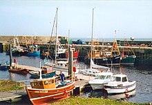
[41] Much of the population of approximately 13,000 inhabitants are situated in small coastal communities, such as Helmsdale and Lochinver, which until very recently made much of their living from the rich fishing of the waters around the British Isles.
Much of Sutherland is poor relative to the rest of the UK, with few job opportunities beyond government-funded employment, agriculture and seasonal tourism.
Despite being Scotland's fifth-largest county in terms of area, it has a smaller population than a medium-size Lowland Scottish town.
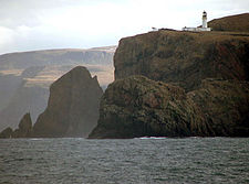
The county has numerous beaches, a remote example being Sandwood Bay, which can only be reached by foot along a rough track.
The spectacular scenery has been created by denudation to form isolated sandstone peaks such as Foinaven, Arkle, Cùl Mòr and Suilven.
Together with similar peaks to the south in Wester Ross, such as Stac Pollaidh, they have a unique structure with great scope for exploration.
On the other hand, care is needed when bad weather occurs owing to their isolation and the risks of injury.
The larger inland lochs are:[b] Owing to its isolation from the rest of the country, Sutherland was reputedly the last haunt of the native wolf, the last survivor being shot in the 18th century.
The importance of the county's scenery is recognised by the fact that four of Scotland's forty national scenic areas (NSAs) are located here.
[43] The purpose of the NSA designation is to identify areas of exceptional scenery and to ensure its protection from inappropriate development.
The areas protected by the designation are considered to represent the type of scenic beauty "popularly associated with Scotland and for which it is renowned".
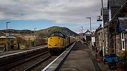
It enters Sutherland near Invershin and runs along the east coast as far as possible, but an inland diversion was necessary from Helmsdale along the Strath of Kildonan.
Buses operate about every two hours Mondays-Saturdays and infrequently on Sundays from Helmsdale to Brora, Golspie, Dornoch, Tain and Inverness in the south, and Berriedale, Dunbeath, Halkirk, Thurso and Scrabster in the north.
Various other Stagecoach buses link the other towns of eastern Sutherland, such as Lairg and Bonar Bridge to Tain and Inverness.
In the Scottish Parliament, Sutherland is represented also as part of the Highlands and Islands electoral region.
The winning design has black lines on a white background, arranged as an overlapping saltire and Nordic cross, representing combined Scottish and Norwegian heritage.
[59] In M. C. Beaton's Hamish Macbeth mystery series, the fictional towns of Lochdubh and Strathbane are located in Sutherland.
The short story "Monarch of the Glen" by Neil Gaiman is set in Sutherland, and includes a discussion on the origin of the name.