Sweet Track
The track extended across the now largely drained marsh between what was then an island at Westhay and a ridge of high ground at Shapwick, a distance close to 1,800 metres (5,900 ft) or around 1.1 mi.
Following its discovery in 1970, most of the track has been left in its original location, with active conservation measures taken, including a water pumping and distribution system to maintain the wood in its damp condition.
In the early fourth millennium BC the track was built between an island at Westhay and a ridge of high ground at Shapwick close to the River Brue.
[4] The remains of similar tracks have been uncovered nearby, connecting settlements on the peat bog; they include the Honeygore, Abbotts Way, Bells, Bakers, Westhay, and Nidons trackways.
Investigation of the Meare Pool indicates that it was formed by the encroachment of raised peat bogs around it, particularly during the Subatlantic climatic period (1st millennium BC), and core sampling demonstrates that it is filled with at least 2 metres (6.6 ft) of detritus mud.
[9] The company for which he worked, E. J. Godwin, sent part of a plank from the track to John Coles, an assistant lecturer in archaeology at Cambridge University, who had carried out some excavations on nearby trackways.
[2][14] This dating led to claims that the Sweet Track was the oldest roadway in the world,[15][16] until the discovery in 2009 of a 6,000-year-old trackway built in 4100 BC, in Plumstead, near Belmarsh prison.
[17] Analysis of the Sweet Track's timbers has aided research into Neolithic Era dendrochronology; comparisons with wood from the River Trent and a submerged forest at Stolford enabled a fuller mapping of the rings, and their relationship with the climate of the period.
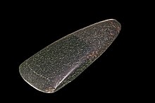
[21] Because of the difficulty of working this material, which was derived from the Alpine area of Europe, all the axe heads of this type found in Great Britain are thought to have been non-utilitarian and to have represented some form of currency or be the products of gift exchange.
[23] Wooden artefacts found at the site include paddles, a dish, arrow shafts, parts of four hazel bows, a throwing axe, yew pins, digging sticks, a mattock, a comb, toggles, and a spoon fragment.
[26] Before this human incursion, the uplands surrounding the levels were heavily wooded, but local inhabitants began to clear these forests about this time to make way for an economy that was predominately pastoral with small amounts of cultivation.
[28] The need to reach the islands in the bog was sufficiently pressing for them to mount the enormous communal activity required for the task of stockpiling the timber and building the trackway, presumably when the waters were at their lowest after a dry period.
[1] The wetland setting indicates that the track components must have arrived prefabricated, before being assembled on site,[30] although the presence of wood chips and chopped branches indicates that some trimming was performed locally.
[42] Following purchase of land by the National Heritage Memorial Fund, and installation of a water pumping and distribution system along a 500-metre (1,600 ft) section, several hundred metres of the track's length are now being actively conserved.
[5] Sections of the track have been designated as a scheduled monument,[1] meaning that it is a "nationally important" historic structure and archaeological site protected against unauthorised change.