Royal Botanic Garden, Sydney
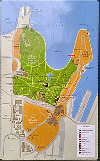
The garden is bordered by the Cahill Expressway to the south and west, Macquarie Street to the northwest, Art Gallery Road to the east, and Sydney Harbour to the north.
After a succession of colonial botanists and superintendents, including the brothers Richard and Allan Cunningham, both also early explorers, John Carne Bidwill was appointed as the first Director in 1847.
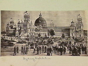
[2] Other work completed under Moore's extensive tenure included:[2] The Garden Exhibition Palace was built on land between the Government House stables (now the Conservatorium of Music) and Governor Bourke's statue, an area until then used for grazing.
[citation needed] Under the dome was a statue of Queen Victoria; there were four corner towers, and a floor area of over 3 hectares (8.5 acres), making it a major landmark in the city landscape.
The same year, Tarpeian Way, including a stone stairway of 53 steps, was cut out of the rocky escarpment north of Bennelong Point, forming a south east boundary to the gardens.
The Way itself may be regarded as the highest level pathway of the street, and precautions have, by the erection of a dwarf wall and iron railing, been taken to prevent people falling over the rock.
By-and-bye the Way, which at present is simply gravelled, and has a watercourse along it, will be asphalted; and the face of the rock Mr. C. Moore intends shall be beautified with creepers in a manner similar to that adopted in the Argyle Cut.
Eventually, we are informed, the way will be widened by the annexation of a small point of ground, which at present is enclosed by a fence, although for all purposes of foot traffic it is sufficiently wide already.
'Its history is as follows : When Mr. J. S. Farnell, the present member for St. Leonards, first assumed the position of Minister for Lands, he was induced by Alderman C. Moore to visit the locality in which it is situated, and to inspect the plans which Mr. E. Bradridge, the late City Surveyor, had prepared for carrying it out.
Objections were at first raised against the width of the way being taken from the Government House grounds; but after some deliberation, and when it was explained that it would be only utilised by pedestrians, they were waived, and the work was permitted to proceed.
Grant arrived in the colony in 1878 and worked first at Yaralla, Concord for the Walkers for some considerable time, then at Rosemont, Woollahra for Alexander Campbell MLC, then for Mr Tooth at the Swifts, Darling Point, which he planned and laid out.
It is likely that the positions at Yaralla and Rosemont both included quarters for a single man and that only after he married Margaret Stevenson in January 1880 was he obliged to find alternative accommodation (Willow Cottage).
[6][2] Towards the end of his time as Director, Moore, together with Ernst Betche, published the Handbook of the Flora of New South Wales, further establishing the Botanic Garden as a centre for the science of botany.
In 1883 the zoo was relocated to Moore Park; and 2 hectares (5 acres) of Outer Domain were incorporated into the Lower Garden, completing the ring of waterfront along Farm Cove.
During the 1880s the Tarpeian Rock was a prominent, dramatic and significant sandstone cliff landscape feature on the north west boundary of the Domain facing Bennelong Point and the Sydney Opera House, cut for the extension of Macquarie Street.
A new Garden entrance was made on Macquarie Street with pools and prostrate plants, and recycled sandstone and iron gates from the post-Garden Palace fire.
The Brown building had three levels housing the herbarium collection in 55,000 specially-designed red plastic boxes, plus scientific staff offices, a laboratory, scanning electron microscope and full drying room and library.
Considerable upgrade works were undertaken in the run up to the 2000 Sydney Olympic Games, including adaptation of existing buildings for new central shop and toilets.
[2] In 2005 the fourth on-site Rose Garden near the Conservatorium and its adjoining pergolas were altered with additions made to both to allow functions, set up and preparation facilities, and a new amenities block.
The roosting activities of the bats had caused the death of a number of highly significant trees and previous attempts using noise, sprinklers and lights had proved ineffective in encouraging the animals to move.
[14][2] In 2016 the Royal Botanic Garden celebrated its 200 years anniversary with various events to commemorate key educational, horticultural, scientific and cultural experiences of those two centuries.
The Upper garden comprises the southern section housing administrative offices and National Herbarium on Mrs Macquarie's road as well as the nursery and depot area bordering the Cahill Expressway.
Some of the Lower Garden was laid out by Charles Fraser and features ponds which are frequented by waterfowl including Australian Black Swans which breed successfully in the environment.
The land before the first Government House and Bennelong Point was laid out in the manner of an English park, the Botanic Garden was treated in a purely functional way.
[26] This plan was subsequently held up for several years by court action instigated by an animal welfare group but approval was finally given to the trust to proceed in June 2012.
[28] In an ironic coda, many of the bats displaced from the garden were found to have moved to a native bushland site on the north coast of New South Wales which was scheduled to be destroyed for an upgrade of the Pacific Highway, the main road linking Sydney with Brisbane.
The destruction of the forest and displacement of that colony became a publicly contentious environment-versus-development issue in early 2014 and the building of the road was delayed pending a court-ordered federal government environmental assessment.
Because of its scale, location and configuration, it plays a crucial role in the approach and entry experience, setting, and definition, of the Sydney Opera House site.
'[35] Its traces of anti-Vietnam War graffiti dating from the 1970s are of State significance as a remnant of an important Australian social movement in a major public space.
The Tarpeian Way is of local significance for its associations with politicians and bureaucrats who authorised and undertook the cutting in 1880 including Sydney Alderman C. Moore, J. S. Farnell, then Minister for Lands, E. Bradridge, City Surveyor and Mr. Moriarty, the Engineer for Harbours and Rivers.