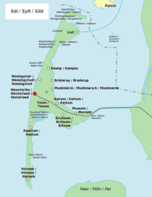
Sylt
Sylt (German pronunciation: [ˈzʏlt] ⓘ; Danish: Sild; Söl'ring North Frisian: Söl) is an island in northern Germany, part of Nordfriesland district, Schleswig-Holstein, with a distinctively shaped shoreline.
It is frequently covered by the media in connection with its exposed situation in the North Sea and its ongoing loss of land during storm tides.
The northern and southern spits of Sylt are exclusively made up of infertile sand deposits, while the central part with the municipalities of Westerland, Wenningstedt-Braderup and Sylt-Ost consists of a geestland core, which becomes apparent in the form of the Red Cliff of Wenningstedt.
Like the mainland geestland, it was formed of moraines from the older ice ages, thus being made up of a till core, which is now apparent in the island's west and centre by the cliff, dunes and beach.
This sandy core began to erode as it was exposed to a strong current along the island's steep basement when the sea level rose 8000 years ago.
The west coast, which was originally situated 10 kilometres (6 miles) off today's shore, was thus gradually moved eastward, while at the same time the island began to extend to the north and south.
In 1141, Sylt is recorded as an island, yet before the Grote Mandrenke flood it belonged to a landscape cut by tidal creeks and, at least during low tide, it could be reached on foot.
[3] Severe storm surges of the last decades have repeatedly endangered Sylt to the point of breaking in two, e.g. Hörnum was temporarily cut off from the island in 1962.
Measures of protection against the continuous erosion date back to the early 19th century when groynes of wooden poles were constructed.
The four-armed structures, built in France and many tons in weight, were too heavy for Sylt's beaches and were equally unable to prevent erosion.
Thus storm floods would only erase the artificial accumulation of sand, while the shoreline proper remains intact and erosion is slowed down.
The required budget of an annual €10 million is currently provided by federal German, Schleswig-Holstein state and EU funds.
[10] In parallel to the ongoing sand flushing, the deliberate demolition of groynes has begun amid great effort at certain beach sections where they were proven largely ineffective.
Measurements showed that, unlike in former times, the wave energy of the sea is no longer lost offshore, today it carries its destructive effects on to the beaches proper.
Also the grazing of sheep on the sea dikes and heaths of Sylt eventually serves coastal management, since the animals keep the vegetation short and compress the soil with their hooves.
Until the mid 19th century, Sylt was an island almost completely devoid of trees except for small areas of forest and bush created by plantations.
Today, one can still recognize the man-made origin of the Friedrichshain and Südwäldchen forests in Westerland where many of the trees stand in rank and file.
[11] The ample heaths on the eastern side of the island provide habitats for many rare species of plants and animals which are adapted to the extreme conditions such as drought, warmth, wind.
[13] The many water birds and other coastal avians that have their hatching grounds on Sylt or use the island for resting on their migrations constitute an ornithological feature.
There are two notable hatching areas on Sylt, the Königshafen bay with the small island Uthörn in the north and the Rantum basin in the southeast.
List in the very north of the island constitutes Germany's northernmost municipality; it retained a certain independence due to its remote location and its long-time adherence to the kingdom of Denmark.
On its eastern shore, a harbour is located where, in addition to tourist ships, the "Sylt-Express" ferry-boat sails to Havneby on the Danish island of Rømø.
South of Westerland, the island extends for about 15 km (10 miles) in the form of a spit, until it is cut by the Hörnumtief tidal creek that runs through the Wadden Sea mudflats east of Sylt.
The name Budersand in the area emanates from that custom, marking a great dune where booths (German: Buden) stood in former times to serve as shelters.
Each year great amounts of sand are washed away by storm floods and coastal management has not yet seen sustainable effects in the area, so that further losses have to be expected.
Geographically, Sylt was originally part of Jutland (today Schleswig-Holstein and mainland Denmark), with evidence of human habitation going back to 3000 BC at Denghoog.
Since Højer was ceded to Denmark in 1920, a rail causeway to the mainland was built in 1927, the Hindenburgdamm, named after Paul von Hindenburg.
During World War II, Sylt became a fortress, with concrete bunkers built below the dunes at the shore, some of which are still visible today.
Sylt is mentioned in a pangram, a sentence that uses every letter in the German alphabet, including every umlaut (ä, ö, ü) plus the ß: Victor jagt zwölf Boxkämpfer quer über den großen Sylter Deich ("Victor chases twelve boxers across the Great Levee of Sylt").
Contemporary artists include the painters and sculptors Rainer Fetting and Ingo Kühl, who live in Berlin and on Sylt.