Tall Zira'a
Its almost continuous stratigraphy from Early Bronze Age to the Islamic periods can possibly demonstrate the history of northeast Jordan.
Tall Zira'a is a large hill some 4.5 kilometres (2.8 mi) south-west of the ancient Decapolis city of Gadara in northern Jordan.
The settlements were built on top of a natural limestone hill, which has a dimension of about 240 metres (790 ft) in diameter at its base.
An artesian well is located in the centre of the hill, which used to provide water in abundance, but dried up rapidly in the last years due to excessive pumping by the owners of the surrounding olive tree plantations.
The south flank of the tall offers the best opportunity to overcome the 22–25 m difference in altitude comfortably via a 150 metres (490 ft) long, ascending track from west to east.
In the Wadi el-'Arab, one can find traces of human activities and settlement places from all periods, dating back to the Paleolithic.
Tall Zira'a – the most important site in this area – was used for settlement from the Early Bronze Age up to 1900 CE.
In March 1978, a two-day archaeological rescue investigation was initiated by the Department of Antiquities into the course of the Wadi el-'Arab dam project.
The long-term archaeological project (2001–2015) investigates the Wadi el-'Arab region, which extends over 25 square kilometres (9.7 sq mi).
In August 2001, a survey on Tall Zira'a (5.88 hectares (14.5 acres)) and in its surroundings was conducted by the Biblical Archaeological Institute Wuppertal, directed by Dieter Vieweger.
It is a unique case in northern Jordan that we have the opportunity to observe the transition from the Middle to the Late Bronze Age culture.
Several observations indicate that the tall was the centre of a Late Bronze Age city state: The strong fortifications, the massive architecture, the high percentage (5%) of imported pottery from Cyprus and Greece as well as the numerous noteworthy single finds.
Three drainage channels from the residential area end in one of the casemates – originally covered with flat stone slabs.
At this point, the water flowed into a semicircular basin from where it drained into a deep, almost circular shaft lined with undressed stones.
To date, three courtyard houses and parts of another two very monumental elaborate buildings north and south of the area have been excavated.
It would seem that the seals, together with a silver pendant decorated with a standing figure (5.8 x 3.4 centimeters), a large scarab amulet (3.7 x 2.4 x 1.4 centimeters) and dozens of beads, fell to the ground from a higher surface (a table, cupboard or shelf) during the destruction of the house and were left scattered over the floor.
Overall 39 cylinder seals ere found in the Late Bronze Age context, mostly quartz and of the Mitanni stype.
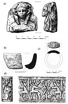
[3] The wealth of the city and its wide-reaching trade links are reflected in the manifold finds of this period (scarabs, terracotta figurines, outstanding bronze objects, a calcite vessel carved with figures of birds, imported faience wares from Egypt include vessels with papyrus images and rings with seals, imported pottery from Cyprus and Mycenaean Greece).
The architecture of the Iron Age IIA/B stratum (10th–8th century BCE) suggests that the tall’s population increased in this period and that the settlement developed an urban character.
Until now, building remains of the Iron Age II settlement give the impression that the architecture was densely agglomerated.
There are several exposed areas that show that the Iron Age houses were separated from one another by a double wall so that the boundaries of buildings and property are clearly visible.
The building layout of the later phase of Iron Age II is characterised by an obvious rearrangement of the houses, though not the city wall.
In the public area the depot for oil pithoi of the older phase had apparently been closed and the large storage pits changed into a paved courtyard with a massive working stone.
It was furnished with a bench along the wall and a large cylindrical, very carefully cut limestone workbench (60 cm in diameter).
A thick wall of dressed stones constructed with stretchers and headers, which is visible halfway down the slope to the east of the tall, suggests that the settlement was fortified.
In fact, it is possible that the fortification of such a densely inhabited settlement was necessary in the 3rd/4th century when the political situation in Palestine became unstable.