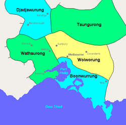
Taungurung
[1] Their Country is to the north of the Great Dividing Range in the watersheds of the Broken, Delatite, Coliban, Goulburn and Campaspe Rivers.
[4] The Howqua River valley contains a number of archaeological sites of significance including at least two quarry sites for greenstone, an exceptionally hard rock used for stone axes, spears and other cutting tools which the Taungurung traded with other tribes.
[6] In February 1859 some Wurundjeri elders, led by Simon Wonga (aged 35) and brother Tommy Munnering (aged 24) petitioned Protector William Thomas to secure land on behalf of the Taungurung clans for the Kulin at the junction of the Acheron and Goulburn rivers in Taungurung territory.
Initial representations to the Victorian Government were positive, however the intervention of the most powerful squatter in Victoria, Hugh Glass, resulted in their removal to a colder site, Mohican Station, which was not suitable for agricultural land and had to be abandoned.
[1][7] In March 1863 after three years of upheaval, the surviving leaders, among them Simon Wonga and William Barak, led forty Wurundjeri, Taungurung (Goulburn River) and Boonwurrung people over the Black Spur and squatted on a traditional camping site on Badger Creek near Healesville and requested ownership of the site.