Taylor County, Wisconsin
[2] It is mostly rural, lying roughly where corn and dairy farms to the south give way to forest and swamp to the north.
A band of Huron Indians from eastern Ontario had fled the Iroquois and taken refuge near the headwaters of the Black River, probably around Lake Chelsea in the northeast part of the county.
Father René Menard, a French Jesuit priest who had travelled up the Great Lakes as far as Keweenaw Bay in upper Michigan, heard that these Hurons were starving.
In mid-summer, he and a French fur trader set out, following rivers and streams in birchbark canoes down into Wisconsin.
Finally, a day's journey from the Huron camp, Father Menard separated from his travelling companion at a rapids to carry some supplies.
The place where he disappeared is believed to be the dells of the Big Rib River, below Goodrich in the southeast corner of Taylor county.
They were working for the U.S. government, marking a north–south line called the Fourth Principal Meridian, from which much of the land in the state would be measured.
For six days they worked their way through woods and swamps, up what is now the southern part of E and across the valley that is now the Mondeaux Flowage, before continuing north into what is now Price County.
The head of the team wrote of the trip: During four consecutive weeks there was not a dry garment in the party, day or night... we were constantly surrounded and as constantly excoriated by swarms or rather clouds of mosquitoes, and still more troublesome insects...[6]On their way through the county, they and other surveyors recorded a forest then dominated by hemlock, yellow birch and sugar maple, with white pine the fourth or sixth most frequent.
The mix of tree species then resembled today's Gerstberger Pines grove southeast of Rib Lake.
The Wisconsin Central's financiers were from Boston, and they named stations at Medford, Chelsea and Westboro after towns in Massachusetts.
To finance building this line, the U.S. Government gave the railroad half the land, the odd-numbered sections, of a good share of the county.
[12] From around 1902 to 1905, the Stanley, Merrill and Phillips Railway built its railroad up the west end of the county through Polley, Gilman, Hannibal and Jump River.
In 1902 the Eau Claire, Chippewa Falls, and Northeastern Railroad (better known as Omaha) pushed in from Holcombe through Hannibal to now-abandoned Hughey on the Yellow River.
In 1905 the Wisconsin Central Railroad built its line through Clark (now a ghost town), Lublin, Polley, Gilman and Donald, heading for Superior.
The SM&P and Omaha were primarily logging railroads, which hauled out lumber and incidentally transported passengers and other cargo.
Initially they tried making their living in various ways: selling milk, eggs, beef and wool, growing cucumbers and peas, and various other schemes.
[16] Soon after, Civilian Conservation Corps camps at Mondeaux, Perkinstown, and near the current Jump River fire tower began to replant parts of that cutover.
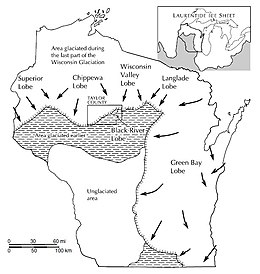
The ice sheet pushed down that far, then melted back, leaving the band of choppy hills and little lakes that cuts diagonally across the county.
North and west of the moraine, in the corner of the county toward Jump River, that last glacier left behind a more gently rolling plain of glacial till.
Here too they left glacial till, but the land is generally flatter and less rocky since erosion has had more time to level things.