Teiaiagon
Teiaiagon was an Iroquoian village on the east bank of the Humber River in what is now the York district of Toronto, Ontario, Canada.
"[1] Percy Robinson's Toronto During the French Regime shows Teiaiagon as being a jointly occupied village of Seneca and Mohawk.
With the removal of the Iroquois from southern Ontario by the Mississaugas,[9] the Anishinaabe and French trade began to flourish in the region shortly after the Great Peace of Montreal of 1701.
James Bâby from Detroit in 1816 acquired the land now called Baby Point and only had orchards located on the site of Teiaiagon.
The Teiaiagon area was acquired by the government for a military fortress and army barracks, but then was sold to Robert Home Smith, who began developing the Baby Point subdivision in 1912.
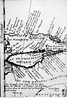
The name "Teiaigon" appears on a 1688 map of New France drawn by Jean-Baptiste-Louis Franquelin based on "sixteen years' of observation of the author".
[5] In the late 1990s and early 2000s another excavation, conducted as a result of installation of a natural gas line to the residential neighbourhood, discovered the burial plots of two Seneca women, which were dated to the 1680s.
[5] One of the women was buried with a moose antler comb engraved with a rattlesnake-tailed panther, "possibly representing Mishipizheu",[12] which morphs into a bear.