Temerin
The territory of the Municipality of Temerin covers the area of around 170 km2 (66 sq mi), and has a shape of an irregular trapezoid, spreading in the northwest to southeast direction.
In regard to relief shapes of Vojvodina, the entire territory of the municipality is located in a south loessial ridge of Bačka, leaving the impression of an almost-flat surface.
In written documents, Temerin is mentioned for the first time in 1332 in the receipt by the pope, issued to Laurentius de Temeri, the parish priest, for the payment of the papal tax.
After that battle, the settlement first became part of the Serb state of emperor Jovan Nenad (1526-1527) and was subsequently included into the Ottoman Empire, which controlled the area until the end of the 17th century.
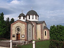
Given Temerin's past wealth, local Serbs built an Orthodox church between 1746 and 1749 and dedicated it to Christ's ascension into Heaven.
Johan Milner built the church with assistance and coordination of Visarion Pavlović, the bishop of Bačko-Segedinska eparchy.
Among church school students is also one of the most notable people from Temerin: the writer, theology professor bishop, and polyglot Lukijan Mušicki, born in 1777 in the town.
Count Sándor Szécsen tried to turn Serbs into his peasants which resulted in their four years long attempt (from 1796 to 1800) to annex Temerin to the Military Border and its nearest unit battalion of Šajkaš.
Document was called “a listing of all Orthodox families from Temerin who came out for migration to the military battalion in the Paška barren area”.
In the spring of 1800 they tore down their houses and their church and carried all of its building material to Paška barren area where they founded new village named Đurđevo.
For next 120 years Temerin was almost without Serbs, count Szécsen brought Hungarian settlers, peasants from counties Pest, Fejér and Tolna.
Szécsen family sold the Temerin property and "Kaštel" / "Кastély" to grain merchant Antal Fernbah from Apatin.
Ana and Petar Fernbah were his heirs and they kept complete Temerin property until agrarian reform in the Kingdom of SHS (Serbs, Croats and Slovenes) in 1920.
In clashes it was burned completely and the settlers migrated to the north, in Bačka Topola, Mali Iđoš, Čantavir and other settlements.
That started industrial development of Temerin, putting into operation one brick plant and first steam mills.
In the period 7 to 9 January 1942 48 inhabitants of the town, 42 Jews, and 6 Serbs, were killed during a series of massacres commonly known as the Novi Sad Raid.
During the 1960s and 1970s several hundred families from village Vrbljani (the Municipality of Ključ, Bosnia and Herzegovina) migrated to the local community Staro Đurđevo.
The third road is one with regional importance (R-120), going through Novi Sad, Bački Jarak and Temerin and leading to Bečej, Senta and Kanjiža.
Through the southeast part of the municipality and its two settlements—Bački Jarak and Temerin, leads a railway from Novi Sad to Žabalj, Bečej and Senta.
If we study relief the southern part of Bačka (in Vojvodina) and we can single out few geomorphological shapes based on soil composition and its genesis.
Total area of the Municipality of Temerin is placed in the eastern part of south loessial ridge of Bačka.
Heights above sea level vary from 81 m to 83 m. Monotony of Bačka plain is disturbed only by lonely hillocks and valleys of smaller water currents.
These distances are even bigger because of Dinarics and Alps mountain ranges which keep the humid airstreams coming from seas and oceans away.
Airstreams, influencing weather changes through the year, are conditioned by unequal warming of Earth surface and different atmospheric pressures above Adriatic and Mediterranean, Atlantic Ocean and wide Euro-Asian land.
There are no longer any natural waterways within the Municipality of Temerin, all having been diverted into canals and included in the DTD hydrosystem, and used for agricultural irrigation.
Area of loessial ridge that covers the biggest part of the Municipality of Temerin resembles steppe grassy vegetation.
Field mice and rats live on large areas planted with corn as well as polecats, weasels, ground squirrels, hamsters, hedgehogs and moles.
There are also a lot of other bird species: sparrows, swallows, woodpeckers, starlings, cuckoos, blackbirds, wrens, storks, hooded crows, etc.
In and around water currents live various fishes: carp, bream, robin, pike, perch, as well as other animals: snails, leeches, various frogs, marsh shells, snakes, etc.
The results showed slightly base reaction (rN – 7.8), total mineralization of 2.669 g/L; characteristic ions are sodium (0.708), hydro-carbonate (1.512) and chlorine (0.337).