Myanmar–Thailand border
The border is 2,416 km (1,501 mi) in length and runs from the tripoint with Laos in the north to the Andaman Sea coast in the south.
[1] The border starts in the north at the tripoint with Laos at the confluence of the Kok and Mekong Rivers and, after briefly following the Kok and then the Sai, then proceeds overland to the west via a series of irregular lines through the Daen Lao Range, before turning to the south-west and joining the Salween River.
The border continues southwards down the Malay Peninsula, almost cutting Thailand in two at Prachuap Khiri Khan, before reaching the Isthmus of Kra and the Kraburi River, which it then follows out via a wide estuary to the Andaman Sea.
The maritime boundary then follows coordinates marked by the countries' continental shelf delimitation agreement towards the tripoint with India, which controls the Andaman and Nicobar Islands.
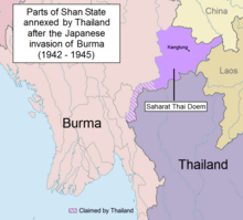
[3][4] In 1868 Britain and Siam signed a treaty delimiting the Burma-Thai border from the Salween south to the Andaman Sea.
[2] In 1892 the northern section of the border delimited and then demarcated on the ground from 1893 to 1894, with a final boundary treaty with maps signed on 17 October 1894.