Thames Conservancy
Its territory was reduced when the Tideway (upper and lower estuary) was transferred to the Port of London Authority in 1909.
[2] Although the commissioners were active in establishing locks and weirs above Staines, they did not interfere with the jurisdiction of the City of London.
The City of London Corporation built a series of locks from Teddington to Penton Hook at the beginning of the nineteenth century.
[4] However trouble arose around 1840 when the government proposed building the Victoria Embankment and the Crown claimed title to the river bed.
In 1858 a toll of 15 shillings was imposed on every steam vessel passing Teddington Lock, and a speed limit set to five miles per hour.
The new authority reaffirmed the rights of anglers against interference from landowners and received a notice from the water bailiff drawing attention to the "improper practice of letting boats for hire to inexperienced persons".
[7] At this time the management of the bulk of the upstream river was the responsibility of the Thames Navigation Commissioners, but this changed in 1866.
It was believed that under single management with the upper river maintained properly and with lower tolls overall the traffic would increase.
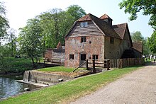
Most weirs belonged to the twenty eight water-mills still operating between Oxford and Staines and the entitlement to water of the mills, many of which dated back to Domesday Book, was recognised.
The Lambeth and Chelsea water companies had moved initially to Seething Wells but later relocated to East Molesey.
In August 1866 the conservancy inspected works between Oxford and Windsor and in October settled a table of tolls.
There were regular complaints at this time about the poor state of river particularly in upper reaches and the persistence of sewage.
The act noted "It is lawful for all persons for pleasure or profit to travel or to loiter upon any and every part or the river" (apart from private cuts).
[23] The conservancy finally addressed navigation above Oxford, replacing the existing weirs with locks and footbridges where there was a right of way.
In 1912 the conservancy undertook major works at Boulter's Lock, which involved the purchase of Ray Mill Island.
The 3⁄4–mile (1 km) cut took the river on a straight course between Weybridge and Walton on Thames, and avoiding a meandering stretch past Shepperton and its Lower Halliford locale.
[29] The channel cut the regularity of flooding in Chertsey and Old Shepperton[30] and halved the distance of travel on that part of the river.
Significant change in the structure of the conservancy in the 20th century began with the passing of the Land Drainage Act 1930.
[33] The Minister of Agriculture and Fisheries could also appoint three additional members after consultation with internal drainage boards.
The act introduced new constitutional, financial and general administrative powers for the river boards, but the Thames Conservancy continued to operate under the 1930 legislation.