The Avenues, Salt Lake City
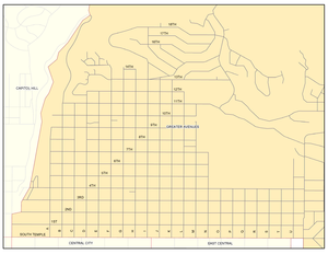
It is named after the perfectly gridlike, closely laid out roads called Avenues (numbers, 1st - 18th) and Streets (letters, A - V).
[citation needed] Many young professionals choose to live there due to the culture and easy commute to downtown.
[citation needed] The Avenues neighborhood lies on the "north east bench" of the Wasatch Mountains in Salt Lake City.
The fairly level east-west roads are numbered 1st to 18th Avenues heading northward from South Temple Street.
The rigid grid system breaks down around 13th Avenue, as more recent developments farther north have taken a more serpentine bend.
Compared to the neighborhoods to the east, the Avenues are in places quite steep as they climb the foothills to the north.
The "lower Avenues" (below 11th or 13th) is a neighborhood of mostly older Victorian-era houses, at one time popular with younger homeowners looking for affordable "fixer-uppers".
The Avenues is also especially popular due to its proximity to downtown, the large and remote Memory Grove/City Creek Canyon recreation area to the west, the University of Utah to the east/southeast, and the airport, as well as low traffic and minimal commercial development.
Shriners Hospital for Children is located on the east side of Virginia Street bordering 11th Avenue.
The Avenues was the first section of Salt Lake City to deviate from the original ten acre (40,000 m2) block grid pattern.
At the turn of the century, the neighborhood was a predominantly middle- and upper-middle class trolley suburb, home to many professionals.
Most homes, built between about 1880 and 1920, showed their age, and the community dealt with increasing problems with transients.
In response to these problems, residents formed the Greater Avenues Community Council (GACC) to help revitalize and restore livability to the neighborhood.