The Burren
[3] The area includes such natural features as Mullaghmore hill and Ailladie cliffs, and historic monuments such as Poulnabrone dolmen and Caherconnell Stone Fort.
[citation needed] During counter-guerrilla operations in The Burren in 1651–52, Edmund Ludlow stated, "(Burren) is a country where there is not enough water to drown a man, wood enough to hang one, nor earth enough to bury him...... and yet their cattle are very fat; for the grass growing in turfs of earth, of two or three foot square, that lie between the rocks, which are of limestone, is very sweet and nourishing.
[9] The limestones, which date from the Visean stage of the early Carboniferous, formed as sediments in a tropical sea approximately 325 million years ago.
In the north and west it lies on a shelf of Galway granite which supported the upper layers, preventing shifts like those that created the "twisted" hills Knockanes and Mullaghmore.
These top layers protected the underlying limestone from erosion for millions of years before being largely stripped away by glaciers, except in the south west, where they still extend from Doolin to Slieve Elva, Lisdoonvarna, Kilfenora and to the western shore of Lake Inchiquin.
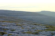
Pre-existing lines of weakness in the rock (vertical joints) contribute to the formation of extensive fissures separated by clints (flat pavement like slabs).
The valleys facing Galway Bay had been widened considerably by glacial action, first when the ice moved south from Connemara and then when meltwater sought a runoff.
[10]: 21 Today, the uplands' highest point is on the hill Slieve Elva, whose shale cover rises to 345 metres (1,132 ft) above sea level.
[4]: 37 Notable insects present in the Burren include the butterflies the pearl-bordered fritillary (Boloria euphrosyne), brown hairstreak (Thecla betulae), marsh fritillary (Euphydryas aurinia) and wood white (Leptidea sinapis); the moths, the Burren green (Calamia tridens, which is only present in Ireland in this area),[4]: 37 Irish annulet (Gnophos dumetata) and transparent burnet (Zygaena purpuralis); the hoverfly Doros profuges and the water-beetle Ochthebius nilssoni.
A wide range of bird species are also found in the Burren, including crows and ravens, peregrine falcons, kestrels and various gulls.
[20] Pollen analysis indicates that in the Mesolithic period of 8000 to 7000 BC The Burren looked completely different from today, with most of the uplands covered in a mixture of deciduous, pine and yew trees.
However, by the Neolithic, c. 4000 BC, settlers had clearly arrived and began changing the landscape through deforestation, likely by overgrazing and burning, and the building of stone walls.
[4]: 7–8 [21]: 5 [22]: 60 The most numerous type of prehistoric structure (apart from stone walls) in The Burren is the late-Neolithic/early-Bronze Age wedge tomb, mostly dated to the period 2500 to 2000 BC.
[4]: 8 However, in contrast to the quantity of archaeological evidence found, the population of The Burren likely declined noticeably between the late Neolithic and the end of the Bronze Age.
This reduction in the area of fertile land put pressure on population numbers and probably increased conflicts over scarce resources.
They were one of dozens of minor tribes in Ireland at that time, which occupied a discrete area (tuath) and were joined by a common bloodline or origin myths.
[24]: 78 The history of these years is uncertain, but after the decline of the Eóganacht Árann the local Corco Modhruadh likely fell under the control of the Uí Fiachrach Aidhne, a tribe from what is now southern Galway, who prospered in the 7th century.
The large number of extant cashels, almost 500 of which have been identified in The Burren (out of around 45,000 in Ireland), also indicates the presence of a sizeable (early) medieval population that supported and used these churches.
They settled at Limerick, but in the Burren only a few artifacts of Scandinavian design have been found, centred mostly on Cahercommaun, which apparently was a major producer of wool at the time.
[21]: 21–4 Either at the end of the 12th or early in the 13th century, Cistercian monks came to the area and established Sancta Maria de Petra Fertili, now known as Corcomroe Abbey.
As late as at the Battle of Dysert O'Dea in 1318 some of the local clans allied to defeat a Norman army led by Richard de Clare.
The villages and towns found within the medieval territory of Boireann include Lisdoonvarna, Ballyvaughan, New Quay (Newquay) / Burrin (Burren), Noughaval, Bealaclugga (Bellharbour), Carron and Fanore / Craggagh.
The Burren has a reputation beyond Ireland, and, most notably with the Cliffs of Moher, but also with the major show caves, dolmens such as at Poulnabrone and other prehistoric sites, and centres of cultural activity, attracts tourists from a wide range of countries.
A key goal is to deal with the challenge of protecting the vulnerable landscape, while at the same time having it provide a fair income for the local inhabitants and allowing it to cope with increased visitor numbers.
Up until quite recently, hardy native breeds of beef cattle were used to graze upland grasslands between the months of October and April, requiring scarcely any dietary supplement prior to their removal to finishing grass elsewhere.
Despite the intensification of agriculture on the uplands[citation needed], population numbers fell from around 4,000 at the beginning of the 20th century to roughly 2,500 by the time of the 1991 Census, before rising once more.
The increasing industrialization of agriculture and the introduction of different breeds of cattle led to shifts in cattle-raising practices – away from winter grazing, which kept down new growth, and towards supplementary feeding.
Typical recommendations enacted included scrub clearance, restoration of drystone walls, reduction in silage usage and a return to winter grazing.
[38][39] The boundary of the Geopark extends from the vicinity of New Quay on Galway Bay, southeast to the Tubber area, then southwest to Corrofin then roughly west towards Doolin and includes the coastal strip containing the Cliffs of Moher.
Taking in a modest sampling of the southeastern Burren, about 1,500 hectares (3,700 acres), it is made up of land purchased by the Irish government to be set aside for conservation purposes.