Catskill Mountains
Geologically, the Catskills are a mature dissected plateau, a flat region subsequently uplifted and eroded into sharp relief by watercourses.
They are well known in American society as the setting for films and works of art, including many 19th-century Hudson River School paintings, as well as for being a favored destination for vacationers from New York City in the mid-20th century.
Nicolaes Visscher I's 1656 map of New Netherland located the Landt van Kats Kill at the mouth of Catskill Creek.
Henry Schoolcraft is supposed to have coined the indigenous term for the range, On-ti-o-ra ("mountains/hills/land of the sky"), in 1844, due to the term not being attested prior to his record of it[5][6][7] The Catskill Mountains are approximately 100 miles (160 km) north-northwest of New York City and 40 miles (64 km) southwest of Albany, starting west of the Hudson River.
At the range's eastern end, the mountains begin dramatically with the Catskill Escarpment rising up suddenly from the Hudson Valley.
The plant hardiness zone on Slide Mountain at 4,180 feet (1,270 m) is 5a with an average annual extreme minimum temperature of −16.6 °F (−27.0 °C).
Slide Mountain and nearby Hunter Mountain average about 63 inches of precipitation annually and most areas within the Catskills still average at least 55 inches annually.New York Climate For the 2nd criteria, summers in the Catskills are indeed cooler, not as hot and frequently cloudy, overcast, and foggy and even frequently chilly overnight as soon as the sun goes down.
The sediments that make up the rocks in the Catskills were deposited when the ancient Acadian Mountains in the east were rising and subsequently eroding.
The uplift and erosion of the Acadian Mountains was occurring during the Devonian[13] and early Mississippian period (395 to 325 million years ago).
A meteor impact occurred in the shallow sea approximately 375 mya, creating a 10 km (6 mi) diameter crater.
By the middle of the Mississippian period, the uplift stopped, and the Acadian Mountains had been eroded so much that sediments no longer flowed across the Catskill Delta.
Grooves and scratches in exposed bedrock provide evidence of the great sheets of ice that once traversed the region.
In the mid–20th century, summer resorts in the Catskills, nicknamed the Borscht Belt, were a major vacation destination for Jewish New Yorkers.
[14] Later changes in vacationing patterns have led most of those travelers elsewhere, although there are still some bungalow communities and summer camps in the region catering to Orthodox populations.
[15] Esopus Creek is a 65.4-mile (105.3 km) tributary of the Hudson River, starting at Winnisook Lake on Slide Mountain.
The Esopus is noted for making an almost 270-degree turn around Panther Mountain, following a buried 6-mile (10 km) impact crater rim.
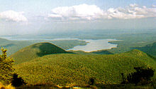
The Ashokan Reservoir is part of the New York City water supply system, with fishing allowed under permit, but swimming and most other recreational uses are forbidden.
In its prime at the turn of the century, visitors included United States Presidents Ulysses S. Grant, Chester A. Arthur and Theodore Roosevelt.
The Catskills are accessible by automobile from the east along Interstate 87/New York State Thruway, which runs north–south through the Hudson Valley.
New York State Routes 28 and 23A cut east–west through the heart of the Catskills, serving many of the most popular outdoor tourist destinations.
Smaller airports in the region include: The Catskills serve as the setting for many works of fiction, such as the short story Rip Van Winkle, and the children's book My Side of the Mountain.
The town of Bethel, New York, located in the Catskills, was home to the famous Woodstock music festival that took place August 15–18, 1969.
The many hotels and vacation resorts located in the Catskills are notable in American cultural history for their role in the development of modern stand-up comedy.
Comedians such as Rodney Dangerfield, Jackie Mason, Alan King, and Don Rickles all got their start performing in Catskill hotel venues colloquially referred to as the Borscht Belt.