Highlands controversy of Northwest Scotland
The northwest highlands region of Scotland is now known to be where part of the Iapetus Ocean closed with the collision of the continents of Laurentia and Baltica about 400 million years ago.
However his explanation involved such large horizontal movements of rock and folding on such a massive scale that he was afraid to publish his results because his theory would seem ridiculous.
[9] The strength of Murchison's views became buttressed by his knighthood in 1846 and when he was appointed director-general of the Geological Survey in 1855 he decided to turn his researches to the little-known and even less understood Northwest Highlands of Scotland expecting to extend his Silurian domain up there.
This geological region runs from the Sleat peninsula of Skye northward through Kyle of Lochalsh, Ullapool and Assynt to Cape Wrath and Loch Eriboll.
[17] In 1827 Murchison had made a cursory survey of the area from the sea but in 1855, hearing news of the discovery of fossils in the limestone at Durness, he visited again with James Nicol, professor of geology at Aberdeen University.
[19] Because of the conditions on the ground they were unable to conduct a thorough geological survey but Murchison considered there was an ascending series (becoming younger) of strata exposed on the surface as one moved west to east.
Following a separate visit in 1856 he claimed that a geological fault ran right down along the northwest coast and that the seemingly younger rocks were in reality far older having been shifted upwards compared with those to the west.
[27] When Nicol announced the results of his latest investigations to the Geological Society in December 1860 he refuted Murchison's findings and rejected the presence of Silurian sediments.
He utterly rejected Murchison's idea that metamorphic rock could lie with no unconformity (with no intervening period of erosion) over unaltered sedimentary layers.
There were often differences of approach and opinion between, on the one hand, members of the Society and, on the other, senior spokesmen and managers of the "professionals" employed in the Geological Survey who carried out most of the actual fieldwork.
From around 1878 papers by members of the Society started to appear, sometimes supporting Nicol and at other times just drawing attention to the inconsistencies in both contemporary theories and the incompatibility of the various field observations.
[38] In 1880 an anonymous letter to The Times was highly critical of the state-funded Survey remarking that it had been set up to be, and should be, a temporary organisation, that it was prolonging its own existence and that the surveyors, rather than being peripatetic, were settling down in particular regions, hence exacerbating the problem.
[43] In 1881 an amateur geologist Charles Callaway surveyed in detail the Durness and Inchnadamph regions and presented a paper to the Geological Society saying the overlying gneiss could not have been formed more recently than the unmetamorphosed limestone below it.
Not deterred by a Geological Survey letter to Nature assuring that Murchison's interpretation would "never be invalidated", the following year Callaway ventured north again equipping him in 1883 to write, according to Oldroyd, "one of the most important documents pertaining to the Highlands controversy".
Because these free-floating creatures had turned to fossils in sedimentation on the sea bed this gave a good indication of the era in which each species had lived and died, regardless of the prior geological stratification of the ground on which they were deposited.
[49] By applying this knowledge over the Southern Uplands as a whole he could tell that, after the fossils had been laid down, the land had often been severely folded sometimes to the extent of being overturned with a single geological layer being duplicated.
At Durness and Eriboll where the layers of rock were most pronounced he could not find fossils sufficiently indicative for his purposes so he had to turn to lithostratigraphy rather than continue with the biostratigraphy he had used so successfully in the Southern Highlands.
[50] "For many years the Highland controversy has appeared to outsiders, and to those geologists who were unaware of the difficulties attending the stratigraphy of the older rocks, as a trivial dispute between the Geological Survey on the one hand and a few misguided amateurs on the other.
[57][58] However, by the following year, after a more southerly survey, Geikie became convinced when he was shown Torridonian sandstone metamorphosed to schist and he wrote in support of the new theory in his preface to Peach and Horne's 1884 report where he made first use of the term "thrust plane".
[64][65][note 7] By the time of Peach and Horne's 1888 paper they were able to extend their analysis of the complex stratigraphy to many more locations along the fault and by 1891 all ideas of Silurian rocks in northwest Scotland had been abandoned.
[67][68] So, confirming Lapworth's view, what Murchison had considered to be Silurian was now identified on the basis of the Durness fossils to be Cambrian and the Torridonian sandstone was placed in the later stages of the Precambrian.
Dealing with the Highlands Controversy, it said that Murchison's theory had never "quite satisfied" Geikie who, for his "love of truth", had delegated to Peach and Horne the task of making a new survey of the region without any preconceptions.
[75][76][note 9] Soon after this an editorial article appeared in the Daily Chronicle condemning the state-funded system in England that allowed eminent establishment scientists to "blunder with impunity".
[note 10] The article continued that Murchison's "absurd theory" had been strongly supported by Geikie who had then instituted a second survey of the whole region, both carried out at the taxpayers' expense.
Peach and Horne continued their work and published The Geological Structure of the North-West Highlands of Scotland in 1907 with Geikie, in his retirement, making the final editing.
[note 12][85] In his preface to the memoir, Geikie refers the area of the Moine Thrust as being a place to study "some of the more stupendous kinds of movement by which the crust of the earth has been affected".
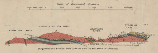
First, along the west coast, the Lewisian complex of gneiss stretches from Cape Wrath to Loch Torridon and then out to the Hebridean islands South Rona and Raasay.
the overlying Torridonian sandstones show gently inclined sedimentary strata with minor faults and joints that have eroded away to form the buttresses of high mountains.
After a long period of marine erosion, the rock that was laid down on top, white over dark red, could be dated as Cambrian, indicating that the Torridonian sandstone was Precambrian.
The consequent Caledonian Orogeny produced intense folding and rocks of what is now called the Moine Supergroup were thrust a distance of some 100 km (60 miles) over the strata at the northwest coast.