The Pale
It had been reduced by the late 15th century to an area along the east coast stretching north from Dalkey, south of Dublin, to the garrison town of Dundalk.
The Oxford English Dictionary is dubious about the popular notion that the phrase beyond the pale, as something outside the boundary—i.e., uncivilised, derives from this specific Irish meaning.
[4] The Pale was a strip of land that stretched north from Dalkey in Dublin to Dundalk in Louth; it became the base of English rule in Ireland.
In the long periods when there was no large royal army in Ireland, the Norman lords, like their Gaelic neighbours in the provinces, acted essentially as independent rulers in their own areas.
The Parliament of Ireland was created, often sitting at Drogheda until the Tudors took a greater interest in Irish affairs from 1485 and moved it back to Dublin.
[5] At a higher social level, there was extensive intermarriage between the Gaelic Irish aristocracy and Anglo-Norman lords, beginning not long after the invasion.
The brief revolt by his son "Silken Thomas" in 1534–35 served in the following decades to hasten the Tudor conquest of Ireland, in which Dublin and the surviving Pale were used as the crown's main military base.
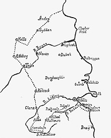
Border or garrison towns of the pale included Ardee, Siddan, Kells, Athboy, Trim, Kilcock, Clane, Naas, Harristown, Ballymore Eustace, Rathmore, Kilteel, Saggart, Tallaght and Dalkey.
The following description is from The Parish of Taney: A History of Dundrum, near Dublin, and Its Neighbourhood (1895):[8] In the period immediately after the Norman Settlement was constructed the barrier, known as the "Pale," separating the lands occupied by the settlers from those remaining in the hands of the Irish.
The entire length of this section is roughly 500 meters and the top of the bank is planted with hedgerow shrubs, indicating that the Pale Ditch subsequently served as a field boundary.
Rather, the builders made use of an existing shallow escarpment, steepening the slope to create a 2 meter high barrier to movement from north to south.
That this feature was part of the Pale Ditch was originally proposed by Rob Goodbody in the 1990s,[9] and recently confirmed by archaeology during the building of the Clay Farm housing development.
[10] Both the sections described above are part of a single linear earthwork, designed to connect Kilgobbin and Carrickmines castles, fortifications built by the Walsh Family during the medieval period to defend the southern marches of the Pale.
This was in large part due to their relative reluctance to give up Roman Catholicism (those who did not worship in the Church of Ireland bore a variety of legal disabilities).