The Volcano (British Columbia)
It is located approximately 60 kilometres (40 miles) northwest of the small community of Stewart near the head of Lava Fork.
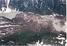
With a summit elevation of 1,656 metres (5,433 feet) and a topographic prominence of 311 m (1,020 ft), it rises above the surrounding rugged landscape on a remote mountain ridge that represents the northern flank of a glaciated U-shaped valley.
This forms part of the much larger Northern Cordilleran Volcanic Province, which extends from the Alaska–Yukon border to near the port city of Prince Rupert, British Columbia.
[2][3] Its structure is poorly formed and has been reduced by erosion from alpine glacial ice found at its elevation and latitude.
It represents one of the few historically active volcanoes in the Northern Cordilleran Volcanic Province, with a base elevation estimated to be 100 m (330 ft).
[5] Like other Iskut-Unuk River Cones, The Volcano has its origins in continental rifting—a long rupture in the Earth's crust where the lithosphere is being pulled apart.
This incipient rifting has formed as a result of the Pacific Plate sliding northward along the Queen Charlotte Fault, on its way to the Aleutian Trench.
[7] As the continental crust stretches, the near surface rocks fracture along steeply dipping cracks parallel to the rift known as faults.
[5] At the southern end of one of the lava flows, it spreads into a broad terminal lobe on the flat alluvial plain of the Unuk River.
[6] Volcanic ash and lava from The Volcano still linger on small glaciers near Mount Lewis Cass, a 2,094 m (6,870 ft) high mountain near the Alaska–British Columbia border.
[10] At least one lava flow from The Volcano was notified by a surveyor named Fremont Morse in 1905 during a survey for the International Boundary Commission.
[5] The Volcano, its eruptive products and a large mineral spring are protected in Lava Forks Provincial Park.
[11] Like other Iskut-Unuk River Cones, The Volcano is not monitored closely enough by the Geological Survey of Canada to ascertain its activity level.
The Canadian National Seismograph Network has been established to monitor earthquakes throughout Canada, but it is too far away to provide an accurate indication of activity under the mountain.
Ash and rock fragments (tephra) ejected during lava fountain activity are unlikely to be high enough to disrupt regional air traffic.
[21] The last eruption at The Volcano 150 years ago had a large impact on fish, plant and animal inhabitants in the valley the lava flows travelled through to cross the Canada–United States border.