Thiers ramparts
Since the 11th century, the town has undergone a process of concentric expansion around the ramparts of the lord's castle and the Saint-Genès church.
By the nineteenth century, only the eastern section of the fortifications remained intact, primarily serving as a retaining wall for the sloping terrain of the town.
The initial path remained in the same location; even the construction of the first wall did not result in a significant alteration to the general direction of the path, which entered the enclosure through the "Porte de la Bout" (demolished at the end of the 19th century) at the top of the current rue du Palais and exited by the "Square Tower of the Chancellery" in front of the current rue du Bourg [fr].
[a 2] At the beginning of the 13th century, the town experienced a period of expansion to the north, resulting in the construction of a new wall surrounding the existing houses.
This new neighborhood was served by a significant freshwater spring, later channeled into the Pirou fountain, located close to the initial wall.
The layout of the streets in Thiers remained profoundly shaped by the fortifications, which held unparalleled importance in the city's urban planning.
[c 1] In the sixteenth century, the lordship initiated the construction of a final defensive wall to safeguard the recently developed residential areas on the eastern mountainside, close to the Durolle River and the Vallée des Usines.
These included embrasures, called bouches à feu in the region, which allowed archers or gunners to fire.
As Michel Combronde notes in Représentation graphique de la porte Neufve au début du XVe siècle, many loopholes were also in the city's towers and walls.
[7] From the 17th century onwards, Thiers experienced urban expansion as a consequence of significant economic growth driven by the flourishing cutlery industry [fr] in the region.
At the end of the 18th century, the city planned the destruction of part of the walls to prevent the collapse of poorly maintained sections and to widen traffic routes.
[2] In 1820, a section of the fourth wall was rebuilt, predominantly comprising the structures that supported the city's eastern land holdings.
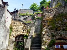
[9] The urban wall of Thiers is notable for its high degree of preservation, with nearly two-thirds of its original structure remaining intact.
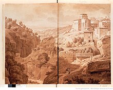
From the Vallée des Usines to the east and the Limagne plain to the west, the city of Thiers is visible as it is built on a rocky spur surrounded by a belt of walls.
This tour, entitled "Thiers, the Medieval", provides an insight into the diversity and richness of the upper city's heritage.
[15] The following elements are described in a clockwise direction, commencing with the Square Tower of the Chancellery, situated to the north of the initial enclosure.
A significant proportion of the original structure has been lost or obscured, with only a limited area remaining accessible today.
Following a renovation project completed in 2017, the tower is now more visible from Place du Pirou as a result of the raised roof.
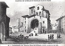
This architectural ensemble is emblematic of a "pedde" in Thiers, and it is designated as Charnier Gate, which was originally part of the Maistre Raymond Tower.
Following extensive renovations in the early 21st century, the Maistre Raymond Tower is now largely visible from the small square it overlooks.
It is the smallest of the towers, with a diameter of just over 3 meters, and contains a staircase allowing residents of the outer districts to enter the fortified town.
Additionally, the tower marks the entrance to an underground passageway connecting the summit of Rue Rouget-de-l'Isle to the Chastel Palace, an early 11th-century structure.
[22] Two unaltered rectangular windows remain in the continuation of the gate: one on the side of Rue des Murailles and the other in a building attached to the church.
They are situated in an atypical landscape, which is regularly painted, drawn, and photographed, especially for illustrating tourist guides and as subjects of postcards.
These included representations of still-visible parts of the ramparts, such as the Maistre Raymond Tower and the Pedde du Coin des Hasards [fr].
[27] Hubert Jaqueton described the town of Thiers as follows: "From the summit of Grun de la Pierre-qui-danse, tourists can survey the entire townscape.