Thwaites Glacier
[1][3] The glacier flows into Pine Island Bay, part of the Amundsen Sea, at surface speeds which exceed 2 kilometres (1.2 mi) per year near its grounding line.
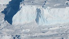
[1] Due to this immense size, enormous mass is shed when the repeated ice calving events occur at the glacier's marine terminus – the point where grounding line is in contact with water.
[30] After breaking off from Thwaites Glacier Tongue, those icebergs ran aground in the Amundsen Sea, about 20 mi (32 km) northeast of Bear Peninsula.
This "melange" of icebergs is still referred to by its old name, as it continues to occupy a substantial amount of area and may retain a stabilizing effect on the glacier.
These researchers have also repurposed a machine learning algorithm normally used in microbiology to identify crevasses in the remains of the ice tongue and project how they may affect its stability.
[18][19][8] However, the accuracy of this hypothesis has been disputed in multiple papers,[36][37][38] and some research suggests that the loss of the ice shelf would result in almost no change to glacier's trajectory.
[11] The largest one to date was discovered by NASA researchers in 2019 – an underwater cavity formed mostly in the previous three years, nearly 350 m (1,148+1⁄2 ft) tall and 4 km (2.5 mi) wide, with an area two-thirds the size of Manhattan.
[42][43] In 2014, the area underneath Thwaites Glacier was found to have heat flow from geothermal activity nearly twice the global average, and about 3.5 times larger in hotspots.
Marie Byrd Land, the location of Thwaites and Pine Island Glaciers, was found to harbor around one volcano per every 11,200 km2 (4,300 sq mi) of area.
[40] At the same time, both Marie Byrd Land and the central rift also contain the majority of West Antarctica's 29 volcanoes whose height exceeds 1 km (0.62 mi), even as they remain completely covered by ice.
This massive size is likely to make them into significant roadblocks to ice flows, and thus gives them the potential to delay glacier retreat in its advanced stages.
[18][43] If all of the ice contained within Thwaites Glacier melted (which is expected to take place over multiple centuries),[5][9][49] it would be sufficient to raise the global sea level by 65 cm (25+1⁄2 in).
[22]: 21 Fears of the entire West Antarctic Ice Sheet (WAIS) being prone to geologically rapid (centuries or even decades) collapse in response to accelerated warming from greenhouse gas emissions have been present since the seminal 1968 paper by glaciologist J.H.
[6][8] This theory was informed by radar measurement data from research flights over West Antarctica in the 1960s and 1970s, which had revealed that in Pine Island Bay, the glacier bed slopes downwards at an angle, and lies well below the sea level.
[8][51] Subsequent research reinforced the hypothesis that Thwaites is the single part of the cryosphere that would have the largest near-term impact on the sea levels, and that it is likely to disappear even in response to climate change which had already occurred.
[13][14][15][16] While some scientists have embraced the name,[55] many others, including leading researchers like Ted Scambos, Eric Rignot, Helen Fricker and Robert Larter have criticized it as alarmist and inaccurate.
[17] In 2001, an analysis of radar interferometry data from the Earth Remote Sensing Satellites 1 and 2 by Eric Rignot revealed that the grounding line of Thwaites Glacier had retreated by 1.4 km (0.87 mi) between 1992 and 1996, while its strongly negative mass balance (annual loss of around 16 billion tonnes of ice, equivalent to 17 cubic kilometers of volume) meant that the retreat was going to continue.
Geophysical data collected from IceBridge campaign flights showed that the most vulnerable parts of Thwaites Glacier sit 1.5 mi (2.4 km) below the sea level.
[9] In 2018, a team of glaciologists, including Eric Rignot, had published projections of Thwaites Glacier contribution to sea level rise for the next 100 years.
[18][50][66] Follow-up ITGC research published in 2023, which observed the underside of the glacier over nine months through a 587 m (1,926 ft)-deep borehole and a robotic mini-submarine called Icefin, found numerous unexpected cracks, or crevasses, where melting proceeded much faster.
At the same time, their research had also found that stratification between the fresh meltwater from the glacier and the salty ocean water caused the overall melting rate to proceed "far less rapidly than predicted by models".
"[5] A 2022 study described the "rapid retreat" of the Thwaites Glacier, inferring its past movement in the pre-satellite era by analyzing "ribs" left behind after seabed gouging by ice.
If confirmed, this would mean that the melting of Thwaites Glacier can be expected to accelerate at a similar rate for the next century, regardless of whether ocean temperature keeps going up, or stops increasing at all.
[75] A 2014 study, using satellite measurements and computer models, predicted that only the lowest possible warming offered any chance of preserving Thwaites Glacier: otherwise, it will inevitably reach the point of "rapid and irreversible collapse" in the next 200 to 900 years.
[9][82] A proposal from 2018 included building sills at the Thwaites' grounding line to either physically reinforce it, or to block some fraction of warm water flow.
[10][82] They also acknowledged that this intervention cannot prevent sea level rise from the increased ocean heat content, and would be ineffective in the long run without greenhouse gas emission reductions.
[10] In 2023, it was proposed that an installation of underwater curtains, made of a flexible material and anchored to the Amundsen Sea floor would be able to interrupt warm water flow.
[23][24][82] To achieve this, the curtains would have to be placed at a depth of around 600 metres (0.37 miles) (to avoid damage from icebergs which would be regularly drifting above) and be 80 km (50 mi) long.
[23][24] Yet, a single seawall capable of protecting the entire New York City may cost twice as much on its own,[82] and the global costs of adaptation to sea level rise caused by the glaciers' collapse are estimated to reach $40 billion annually:[23][24] The authors also suggested that their proposal would be competitive with the other climate engineering proposals like stratospheric aerosol injection (SAI) or carbon dioxide removal (CDR), as while those would stop a much larger spectrum of climate change impacts, their estimated annual costs range from $7–70 billion for SAI to $160–4500 billion for CDR powerful enough to help meet the 1.5 °C (2.7 °F) Paris Agreement target.