Tibbitt to Contwoyto Winter Road
[2][4][5] The winter road is constructed by Nuna Logistics and RTL-Robinson every January and takes about six weeks to complete.
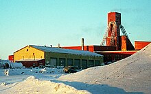
This road began at Discovery Mine which was already connected to Yellowknife by ice road up the Yellowknife River and swung east to Gordon Lake, heading north up Drybones, Lockhart and Mackay Lakes where the Tundra Mine was located.
[9] The road was reopened in 1979 as part of an equipment haul to the new Lupin Mine at Contwoyto Lake, now Nunavut but then the NWT, pioneered by Robinson's Trucking and Hugh Arden.
An experimental operation, Lupin decided not to continue using the road at this time and relied instead on Hercules C-130 aircraft to haul in machinery during construction of the mine.
In 1983, the ice road to Lupin Mine reopened as an economic alternative to yearly freight haul using aircraft.
[12] Det’on Cho is a Yellowknives Dene company with headquarters in N'Dilo and Scarlet Security, based in Yellowknife, is an Alarand affiliate.
A new rule for the Tibbitt to Contwoyto Winter Roads was enacted for the 2008 season prohibiting commercial, media, video or rolling film cameras either inside or attached to the outside of vehicle.
Download coordinates as: The ice road begins about 65 km (40 mi) east of Yellowknife at the end of Highway 4, more commonly known as the Ingraham Trail.
With the closing of the Lupin and Jericho mines, the road is no longer built to Contwoyto Lake.
According to the 2020 JVTC Map book the road is shorted to 367km at the Ekati Mine on Lac De Gras.
The secondary route begins about 20 km (12 mi) east of Yellowknife at Prosperous Lake.map 13 The road heads north across the lake just to the west of Cassidy Pointmap 14 and through Quyta Lake where some of the earliest gold samples were found in 1933.map 15[18] From there the road continues north to Johnston Lakemap 16 and then northeast to Giauque Lake,map 17 with a road heading west to the old Discovery Mine, now the Yellowknife Gold Projectmap 18 operated by Tyhee Development.