Tibesti Mountains
The volcanic activity was the result of a continental hotspot that arose during the Oligocene and continued in some places until the Holocene, creating fumaroles, hot springs, mud pools and deposits of natron and sulfur.
Erosion has shaped volcanic spires and carved an extensive network of canyons through which run rivers subject to highly irregular flows that are rapidly lost to the desert sands.
Tensions continued after Chad and Libya gained independence in the mid-20th century, with hostage-taking and armed struggles occurring amid disputes over the allocation of natural resources.
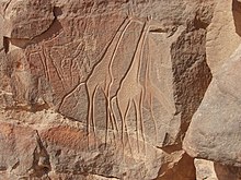
Greater biodiversity existed in the past, as evidenced by scenes portrayed in rock and parietal art found throughout the range, which date back several millennia, even before the arrival of the Toubou.
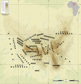
[15][16] It draws a large triangle with sides of 400 km (250 mi)[12] and vertices facing south, northwest and northeast in the heart of the Sahara,[17][18] making it the largest mountain range of the desert.
[34] Several rivers flow radially on the southern slopes of the Emi Koussi before seeping into the sands of Borkou and then reemerging at escarpments up to 400 km (250 mi) south of the summit, near the Ennedi Plateau.
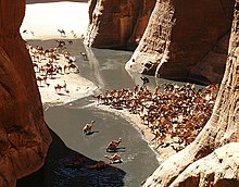
[34] The Mare de Zoui is a small permanent body of water 600 m (2,000 ft) above sea level, located in the northern part of the mountains in the wadi of the Enneri Bardagué, 10 km (6.2 mi) east of Bardaï.
[18][23] The Tibesti Mountains are a large area of tectonic uplift that, according to contemporary theory, resulted from a mantle plume in the craton of the African Plate lithosphere, which is about 130 to 140 km (81 to 87 mi) thick.
[18][50] Due to the comparatively slow movement of the African Plate—roughly between 0 and 20 mm (0 and 0.8 in) per year since the Lower Miocene—there is no relationship between the age of the volcanoes and their dimensions, geographic distribution or alignment, in contrast to hotspots such as the Hawaiian–Emperor and Cook-Austral seamount chains.
Lava flows, minor pyroclastic deposits, and the appearance of small cinder cones, and the formation of the Era Kohor crater are the most recent volcanic activities on Emi Koussi.
[57] Presently,[update] there are reports of volcanic activity in various parts of the massif, including hot springs at the Soborom geothermal field and fumaroles on Tarso Voon, Yi Yerra near Emi Koussi and Pic Toussidé.
[59] The phases of erosion and sendimentation are indicative of the climate alternating between dry and wet conditions, the latter of which fostered vegetation in the Tibesti that was likely significantly denser than that which exists today.
[d][61] Furthermore, the discovery of calcified charophyta (particularly of the family Characeae) and gastropod fossils in Trou au Natron indicates the presence of a lake at least 300 m (1,000 ft) deep during the Late Pleistocene.
[35][65][66] In the south of the range, this variation is largely due to oscillations of the Intertropical Convergence Zone (ITCZ), which steadily moves northward toward northern Chad from November until August, accompanied by humid monsoonal air.
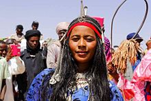
[119] In the 15th and 16th centuries, Al-Maqrizi and Leo Africanus referred to the "country of the Berdoa", meaning Bardaï, the former associating the Toubou with the Berbers and the latter describing them as Numidian relatives of the Tuareg.
Several other clans—the Mogode in the west, Terintere in the north, Tozoba in the center, and Tegua and Mada in the south—are originally clans of the Bideyat people who immigrated from the Ennedi Plateau, southeast of Tibesti, around the same time.
The Mahadena occupy the northeast quarter of the range and are likely from the Jalo oasis of Cyrenaica and thus related to the Mogharba Arab tribes, although an alternative hypothesis is that they are of Bideyat origin.
[126] In 1890, to the chagrin of the Turks, France and Great Britain signed a declaration recognizing a French zone of influence in northern Africa from the Mediterranean Sea down to Lake Chad.
However, French General Edouard Cortadellas admitted their attempts to quell the Toubou were essentially hopeless, remarking, "I believe we should draw a line below [the Tibesti region] and leave them to their stones.
[148] The Chadian government, led by Félix Malloum since Tombalbaye's overthrow in 1975, signed a peace agreement with Habré in 1978, although fighting with other rebel groups, many aligned with Libya, continued.
[165] Following a decade of relative peace, in late 1997 the Tibesti saw the formation of the Movement for Democracy and Justice in Chad (MDJT), a rebel group opposed to Chadian president Idriss Déby.
[174] The arrival of migrants has led to violent conflicts with the Teda locals, a problem exacerbated by an influx of weaponry to the region due to the ongoing[update] wars in Darfur and Libya.
[191] After climbing two peaks situated on a ridge to the north,[i] they attempted Tieroko, but just 60 m (200 ft) from the summit, they were faced with a vertical, crumbling rock wall and were forced to descend.
Following this defeat, they took the opportunity to climb Emi Koussi, 19 years after its first ascent by Thesiger, and also Pic Woubou, a prominent spire located between Bardaï and Aouzou.
[194] The Englishman Eamon "Ginge" Fullen scaled Bikku Bitti, the highest peak in Libya at 2,266 m (7,434 ft), in 2005, capping a successful Guinness World Records attempt.
[100] The Soborom geothermal field, the name of which means "healing water",[j] is known to locals for its medicinal qualities; its pools are rumored to cure dermatitis and rheumatism after several days of soaking.
[203] The banks of the enneris grow desert gourd (Citrullus colocynthis), which are collected in October to extract the bitter seeds which, after being washed, are ground to make flour.
[210] In the early 2010s, the French adventure travel company Point-Afrique financed the repair of the airport at Faya-Largeau, some 200 kilometers (120 mi) southeast of the Tibesti, and established direct charter flights between Faya and Marseille.
Although the flights mainly brought tourists destined for the Ounianga Lakes UNESCO World Heritage Site, there was considerable hope that they would also open the gates for tourism in the Tibesti.
[209] Continuing civil unrest and the presence of landmines pose a danger to tourists, and, despite the occasional tour group, the Tibesti remains one of the most isolated places on Earth.