Mesopotamian Marshes
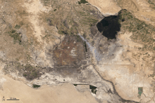
[7][1][2][3][4] The marshes are primarily located on the floodplains of the Euphrates and Tigris rivers bound by the cities of Basra, Nasiriyah, Amarah and a portion of southwestern Iran and northern Kuwait (particularly Bubiyan Island).
Historically the marshlands, mainly composed of the separate but adjacent Central, Hawizeh and Hammar Marshes, used to be the largest wetland ecosystem of western Eurasia.
[12] After the American overthrow of Hussein in 2003, the marshes have partially recovered but drought along with upstream dam construction and operation in Turkey, Syria and Iran have hindered the process.
Modern day Mesopotamia is now occupied by Iraq, parts of eastern Syria, south-eastern Turkey, southwest Iran, and northern Kuwait.
[15] The Central Marshes receive water from influxes of the Tigris's distributaries, namely the Shatt al-Muminah and Majar al-Kabir south of Amarah.
This river plays a critical role in maintaining the Al-Hawizeh marshes as a flow-through system and preventing it from becoming a closed saline basin.
The ecoregion includes both the Mesopotamian Marshes and the Shadegan Ponds, a wetland on the lower Karun River in neighboring Iran.
[17] The marshes are integral to coastal health, filtering out pollutants and waste before they reach the Gulf,[18] though this capacity was significantly degraded after their draining.
[30] Nevertheless, Marsh Arabs remain one of Iraq’s most underserved populations, struggling to obtain healthcare, clean drinking water, and adequate nutrition.
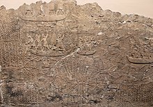
[19] In the 4th millennium BCE, the first literate societies emerged in Southern Mesopotamia, often referred to as the "Cradle of Civilization", and the first cities and complex state bureaucracies were developed there during the Uruk period.
Due to the geographical location and ecological factors of the Fertile Crescent, a crescent-shape fertile area running from the basins of the Nile in Egypt, northwards along the Mediterranean coast in Palestine and Israel, and southwards again along the Euphrates and the Tigris towards the Persian Gulf, civilizations were able to develop agricultural and technological programmes.
Farming arose early in the Fertile Crescent because the area had a large quantity of wild wheat and pulse species that were nutritious and easy to domesticate.
The draining of the marshes was intended at first to reclaim land for agriculture along with oil exploration but later served as a punishment for Shia Arabs in response to the 1991 uprisings in Iraq.
[15] With the exception of the Nasiriyah Drainage Pump Station, the 565 km (351 mi) Third River was completed in 1992 and two other canals were constructed south and nearly parallel to it.
The combined efforts of the Iraq government, United Nations, U.S. agencies and record precipitation in Turkey helped begin a restoration of the marshes.
[41] Recent drought and continued upstream dam construction and operation in Turkey, Syria, and Iran have reduced the marshes to around 30% of their original size by 2009.
"When the river water levels were high, the low-saline Tigris washed over the marshes, cleansed them, and pushed the salty residue into the saltier Euphrates, which flows along the western edge.
"[45] The government prioritizes providing water to cities along the Tigris and Shatt al-Arab, resulting in reduced flow to the marshes.
[34] Temperatures in the region have risen over 0.5 degrees Celsius per decade, causing drought in Iraq and in neighbors whose waters flow into the Tigris and Euphrates.
[35] Massive amounts of untreated sewage and other pollutants are dumped into the Tigris and Euphrates, moving downstream into the marshes and further degrading the water quality.