Time in Mexico
[1][2] Mexican law states that remote islands observe the time zone corresponding to their geographic location.
One time zone based on 105°W (7 hours behind GMT) covered most of the country, from Baja California to Veracruz and Oaxaca.
A second time zone based on 90°W (6 hours behind GMT) covered the southeastern part of the country, comprising the states of Chiapas, Tabasco, Campeche, Yucatán, and the territory of Quintana Roo.
The rest of the country remained in 90°W (6 hours behind GMT), named Hora del Centro (Central Time).
In December 1981, for commercial and tourism reasons, the states of Campeche, Yucatán, and Quintana Roo were changed to time zone 75°W (UTC−05:00).
[24][25] The government of the Federal District issued a decree attempting to also discontinue observing daylight saving time, but the Supreme Court ruled that only Congress had the power to decide on the subject.
The Mexican Congress decided to maintain the existing shorter schedule for Mexico, causing a time difference across the Mexico–United States border during part of the year.
Daylight saving time was discontinued nationally, except in Baja California and some municipalities near the U.S. border, which continued observing it with the U.S. schedule.
At the same time, the entire state of Chihuahua, including areas near the U.S. border, changed to the Central Zone (UTC−06:00 all year).
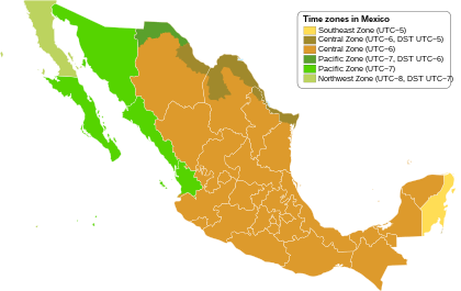
| Mexican time zone | Standard | DST | U.S. equivalent | |
|---|---|---|---|---|
| Zona Sureste | UTC−05:00 | Eastern Standard Time | ||
| Zona Centro | UTC−06:00 | UTC−05:00 | Central Time | |
| UTC−06:00 | Central Standard Time | |||
| Zona Pacífico | UTC−07:00 | UTC−06:00 | Mountain Time | |
| UTC−07:00 | Mountain Standard Time | |||
| Zona Noroeste | UTC−08:00 | UTC−07:00 | Pacific Time | |