Tizard Bank
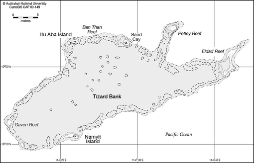
The Tizard Bank, 10°15′N 114°30′E / 10.250°N 114.500°E / 10.250; 114.500 is a partially sunken atoll and one of the significant maritime features of the north-western part of the Spratly Islands.
It was named after Thomas Henry Tizard (1839 – 17 February 1924), a British oceanographer and surveyor who surveyed the bank from aboard HMS Rifleman in the 1860s.
It is 32.05 nautical miles (59.36 km; 36.88 mi) in length, and extends west from the Gaven Reefs to the NW of Dangerous Ground.
The total area is 953 square kilometres (368 sq mi), and the greatest depth of the central lagoon is 80 meters.
[4] The central lagoon generally is 10 to 40 meters deep,[5] although many coral heads have much shallower depths.