Toggenburg
[1] At Wildhaus, the highest village (3,632 ft [1,107 m]), the house wherein Huldrych Zwingli, the Swiss Reformer, was born in 1484, is still shown.
There are traces of the paleolithic Mousterian Industry throughout the Appenzell Alps, in the Toggenburg notably in Wildenmannlisloch cave.
The upper Thur valley was part of the province of Raetia in the Roman era, and was reached by Alemannic-speaking settlers only in the early medieval period.
[1] Part of the Toggenburg followed the Swiss Reformation led by Zwingli, and the valley declared itself independent in 1530, but was forced to re-submit to the Abbot of St. Gall in 1538.
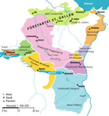
The Abbot was, however, pressured into toleration of either confession, so that the Toggenburg became one of the few regions of Switzerland, where Catholicism and Protestantism have a tradition of co-existence.
In 1707, the Toggenburg again declared its independence of St. Gall, in reaction to the Abbey's plans to build a road across the Ricken Pass, which was seen as a strategic arrangement towards a Catholic military alliance.
The ensuing Toggenburg war of 1712 resulted in a balance of power between Catholic and Protestant cantons, ultimately leading to the formation of Switzerland as a federal state.
Additionally, the InterRegio Voralpen-Express provides long-distance services, from Wattwil to St. Gallen and to Arth-Goldau and Luzern, bypassing Zürich.
From Unterwasser, the Iltiosbahn, a funicular railway, takes passengers to Iltios, from where an aerial tram continues to Chäserrugg (Churfirsten).