Toronto Purchase
In the case of the Toronto area, the Mississaugas of New Credit exchanged 250,808 acres (101,498 ha) of land in what became York County (most of current Toronto and the Regional Municipality of York bounded by Lake Ontario to the south, approximately Etobicoke Creek and Highways 427 and 50 (both part of a now mostly-vanished road known as Indian Line, which was named due to it forming the purchase boundary) to the west, approximately Ashbridge's Bay/Woodbine Avenue-Highway 404 to the east and approximately south of Sideroad 15-Bloomington Road to the north) for some money, 2,000 gun flints, 24 brass kettles, 120 mirrors, 24 laced hats, a bale of flowered flannel, and 96 gallons of rum.
Johnson and Indigenous representatives produced a blank deed, which did not have a land description, leaving the actual purchase incomplete.
Not knowing what the precise boundaries were for the Toronto Purchase, William Claus, the agent for the British Indian Department, met with Indigenous representatives to produce a new treaty.
Claus presented a map showing the Purchase as including the lands from Ashbridge's Bay west to Etobicoke Creek, north 28 miles (45 km) to Simcoe.
For this revision, the Mississaugas of New Credit First Nation also claimed the Toronto Islands, which was not part of the purchase as the agreement only went to the Lake Ontario shoreline.
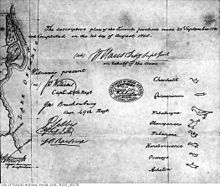
The land sold consists of: The Purchased was signed by Sir John Johnson, William Claus (deputy superintendent of Indian Affairs representing the Crown).
Witness consisted of: British Confirming Indian Chief Totems First Nations Starting in 1986, the Mississaugas opened a land claims settlement process with the Government of Canada to rectify its grievance over the Toronto Purchase and a smaller plot of land near Burlington Bay.
The money was distributed to the band government, with each of the 1,700 present-day Mississaugas receiving $20,000, with the rest placed in trust for future generations.