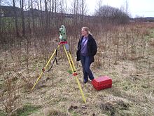
Total station
In theory, this eliminates the need for an assistant staff member, as the operator holds the retroreflector and controls the total station from the observed point.
In practice, however, an assistant surveyor is often needed when the surveying is being conducted in busy areas such as on a public carriageway or construction site.
This is to prevent people from disrupting the total station as they walk past, which would necessitate resetting the tripod and re-establishing a baseline.
This entails witnessing any angles recorded an equal number of times in both "direct" and "reverse" modes by sighting the observed backsight and foresights with the instrument facing the targets normally as well as with the scope flipped or "plunged" 180°.
[3] Measurement of distance is accomplished with a modulated infrared carrier signal, generated by a small solid-state emitter within the instrument's optical path, and reflected by a prism reflector or the object under survey.
[5][6] For this reason, some total stations also have a global navigation satellite system (GNSS) receiver and do not require a direct line of sight to determine coordinates.
However, GNSS measurements may require longer occupation periods and offer relatively poor accuracy in the vertical axis.
Total stations are also employed by archaeologists, offering millimeter accuracy difficult to achieve using other tools as well as flexibility in setup location.
A total station is used to record the absolute location of the tunnel walls, ceilings (backs), and floors, as the drifts of an underground mine are driven.
Because more commercial and industrial construction jobs have become centered around building information modeling (BIM), the coordinates for almost every pipe, conduit, duct and hanger support are available with digital precision.