Tower Rock State Park
[3] The Adel Mountains Volcanic Field is a 3,280-foot (1,000 m) thick unit which lies unconformably on top of Cretaceous sedimentary rock of the Two Medicine Formation on the edge of the Great Falls Tectonic Zone.
The landform is 424-foot (129 m) high, and consists of clear outcrops at the north and south ends connected by a broken saddle ridge.
[16] Thin topsoil covers the base on the north, south, and west sides, with juniper and stunted fir trees, grasses, and sagebrush the dominant plant species.
The Bitterroot Salish and Lower Kootenay often passed by Tower Rock on their way through the Adel Mountains Volcanic Field to hunting grounds.
The Piegan Blackfeet often wintered near present-day Helena, Montana, and passed through the Adel Mountains Volcanic Field by following the Missouri River.
Wickiup frames were often built in the area and reused as native people moved to their summer hunting grounds and back to their winter camps.
Tower Rock marked the boundary where the Lewis and Clark Expedition left the Great Plains and entered the Rocky Mountains.
Starting near dawn on July 16, Lewis took ailing expedition members Jean Baptiste Lepage and John Potts and set out on foot to explore ahead.
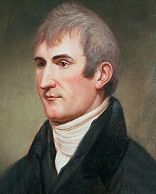
Lewis gave the landmark its name in his journal:[22] at this place there is a large rock of 400 feet high w[h]ich stands immediately in the gap which the missouri makes on it's passage from the mountains; it is insulated from the neighbouring mountains by a handsome little plain which surrounds it[s] base on 3 sides and the Missouri washes it's base on the other, leaving it on the Lard.
Having reached Traveler's Rest (near present-day Lolo, Montana), Lewis and Clark decided to split the expedition in two.
The Ordway group was forced to spend the afternoon and night near Tower Rock before proceeding past Half-Breed Rapids the next day.
In part, this was because easier routes allowed access to the western mountains and valleys, but also because the Piegan Blackfeet continued to claim the area as their own and were notoriously hostile to intruders.
[35] Two years later, however, the railroad contracted with the Diamond R Freight Company to build a wagon road from Helena through the canyon past Tower Rock to the new trading post of Carroll at the headwaters of the Musselshell River.
The "Carroll Trail" was constructed, but closed in 1876 due to hostility from Native Americans and shifts in the Missouri River's channel.
[19] On October 16, 1887, the link between Devils Lake, North Dakota; Fort Assinniboine (near the present-day city of Havre); and Great Falls was complete.
[40][41] The unincorporated hamlet of Hardy was established on the north boundary of Tower Rock as a siding by the Montana Central Railway in 1888.
[42] Named for rancher Rufus Hardy, who in 1866 became the first white settler on the west bank of the river in the canyon, the settlement was given a post office the year it was founded.
In 1921, the state of Montana and the counties of Cascade and Lewis and Clark jointly proposed building a road on the east bank of the Missouri River between the towns of Hardy and Craig.
This route provided both lower construction and maintenance costs, and had the added benefit of allowing Highway 91 to act as a frontage road.
The Northern Pacific gave its title back to the state in a land swap in July 1898, and 160 acres (0.65 km2) of Section 35 (including a portion of Tower Rock) was purchased by white settler Allen Woods in August 1898.
White settle James Austin purchased 134 acres (0.54 km2) of Hardy's land (not including Tower Rock) in November 1907.
[42] The privately owned portion of Tower Rock was acquired by the Montana Department of Transportation (MDOT) in 1957 as part of the land acquisition of I-15 construction.
Although the bill did not pass, MDOT officials paid heed to public sentiment and in February 2004 transferred ownership of the 140-acre (0.57 km2) site enclosing Tower Rock to the Montana Department of Fish, Wildlife and Parks.
[54] Tower Rock State Park is located about 30 miles (48 km) south of the city of Great Falls[55] in Cascade County, Montana.