Transport in Sheffield
Transport in Sheffield, England is developed around the city's unusual topography and medieval street plan.
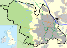
There are eight [1] park and ride sites for motorists visiting the city, three of them close to M1 junctions and offering connections to local public transport.
The Midland Main Line is the major railway through Sheffield, running in approximately a south-west to north-easterly direction.
Passenger rail services through Sheffield are provided by CrossCountry, East Midlands Railway, Northern and TransPennine Express.
The larger Doncaster Sheffield Airport, located 18 miles (29 km) east of the city centre at Finningley, opened on 28 April 2005 with the first flight to Palma de Mallorca, but closure of the airport was announced on 26 September 2022, with the last arrival on 4 November.
London St Pancras station, the terminus of the Midland Main Line, connects with Eurostar services to Europe.
Being at the confluence of several natural waterways, the development of a canal system marked an important evolution in the city's transport network, initially for commercial use and, more recently, for leisure activities.
It connects Sheffield, Rotherham, and Doncaster with the River Trent at Keadby and (via the New Junction Canal) the Aire and Calder Navigation.
The inner ring-road follows St Mary's Road, Upper Hanover Street and then traverses Netherthorpe, to reach Shalesmoor.
Sheffield City Council is belatedly introducing a clean air zone from early 2023, after delaying the plans in 2020.
Sheffield is close to the Peak District National Park, an area of outstanding natural beauty popular with both on and off-road cyclists.
The earliest known roads in the Sheffield area date from the Roman occupation of Britain between 43 and 410 AD.
[20] In the centuries after the end of the Roman occupation the Sheffield area was at the border of the Anglo-Saxon kingdoms of Northumbria and Mercia.
The 1875 plan also called for the widening of High Street, but disputes with property owners delayed this until 1895.
[32] The S&SY Navigation company was formed in 1888 with the intention of purchasing all of the waterways which were then owned by Manchester, Sheffield and Lincolnshire Railway.
The Beeching cuts led to the closure of the Great Central Railway route to London Marylebone in 1966, followed by the Woodhead line to Manchester Piccadilly in 1970.
South Yorkshire County Council (SYCC) was created in 1974, comprising several neighbouring metropolitan boroughs; Sheffield, Barnsley, Doncaster and Rotherham.
The metropolitan county councils created at this time, were given the responsibility for the provision of public transport.
In the case of the SYCC this was allocated to the new South Yorkshire Passenger Transport Executive (SYPTE) that assumed control of the former local corporation bus fleets and also took on a coordinating role regarding the services provided by other bus operators and by British Rail in their region, in addition to becoming the highway authority for the area.
Deregulation of UK bus services in 1986 brought an end to the local authority's direct control of the provision of local bus services, in essence leaving the bus companies to decide where, when and how often to run services, and compete commercially with each other although SYPTE still maintains an advisory role and funds the running of some non-commercially viable routes that are considered socially essential.