Transport in Zagreb
Mass transit is composed of 19 inner-city tram lines and 120 bus routes, both managed entirely by Zagrebački električni tramvaj, commonly abbreviated to ZET.
Zagreb Airport is connected to the Zagreb Bus Station via Pleso Prijevoz shuttle[1] and to Eugen Kvaternik Square via bus line 290 which connects the aforementioned square with the satellite city of Velika Gorica via the Airport.
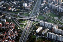
The 18-kilometer (11 mi) Slavonska Avenue is the longest and one of the most congested roads in Zagreb, connecting the inner city to the A3 highway in the east.
Zagreb is struggling with the road infrastructure and the number of available parking spaces being insufficient to meet the demand of such an increase in car ownership.
Donji Grad, the Zagreb downtown, mostly built in the 19th century, features a quasi-rectangular street plan, but the rest of the city depends on the form of wide straight avenues intersecting densely built neighborhoods composed of mostly chaotical street systems.
Summer months are commonly used to repair road infrastructure across the city, due to many of the city residents leaving on holiday leave, thus reducing the load of vehicles and subsequent traffic congestion which would ensue due to roadworks.
After a successful test drive where Bartolović drove mayor Adolf Mošinsky through Mesnička Street and Gornji Grad, the first taxicab stand in the city was opened on the Ban Jelačić Square.
However, a bus network supplements the tram and services a large part of the Zagreb metropolitan area even outside the borders of the city proper.
[4] In 2023, public procurement procedure started for building additional tram lines in Zagreb, specifically connecting Eugen Kvaternik Square via Heinzelova street with the Savišće terminal, and connecting the Zapruđe terminal with the Zagreb goods station.
[17][18] The first tram line was opened on September 5, 1891, setting off a vital part of the Zagreb mass transit system.
TMK 2200 is produced by the Crotram consortium, composed of Končar elektroindustrija and TŽV Gredelj, both from Zagreb.
[11] There is a north-south corridor connecting the neighborhoods of Remetinec (M202) and Sveta Klara (M502), but they are not commonly used due to the time gap between trains arriving being on average longer than an hour and the lack of parking spaces near the aforementioned stations, even though they provide the fastest access from Novi Zagreb to the city centre, with the travel time of 8–9 minutes.
There have been studies to utilize this corridor more efficiently, by building a train station interconnected with the tram terminal at Savski most.,[23] but as of 2024 no progress has been made.
[26] A definitive public transport concept has yet to be decided upon, mostly due to funding issues caused by budgetary constraints.
[32] The river Sava flows through the city, but it is not navigable in Zagreb and the nearest port is located in Sisak.
The city has had a history of flooding,[33] and following the last catastrophic flood in 1964, when inundation affected 60 square kilometres (23 sq mi) of inner-city territory, city authorities had built a system of levées to protect itself from Sava, together with a discharge canal Sava-Odra, completed in 1971.