Transportation in Cleveland
Cleveland's most walkable and transient areas can be found in the Downtown, Ohio City, Detroit-Shoreway, University Circle, and Buckeye-Shaker Square neighborhoods.
In 2008, RTA completed the HealthLine, a bus rapid transit line, for which naming rights were purchased by the Cleveland Clinic and University Hospitals.
It runs along Euclid Avenue from downtown through University Circle, ending at the Louis Stokes Station at Windermere in East Cleveland.
[3] In 2007, the American Public Transportation Association named Cleveland's mass transit system the best in North America.
At the junction with the Shoreway, I-90 makes a 90-degree turn known in the area as Dead Man's Curve, then continues northeast, entering Lake County near the eastern split with State Route 2 (SR 2).
In addition to Hopkins, Cleveland is served by Burke Lakefront Airport, on the north shore of downtown between Lake Erie and the Shoreway.
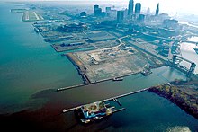
[9] The Port of Cleveland, at the Cuyahoga River's mouth, is a major bulk freight terminal on Lake Erie, receiving much of the raw materials used by the region's manufacturing industries.
[10] In addition to freight, the Port of Cleveland also welcomes regional and international tourists who pass through the city on Great Lakes cruises.
Additionally, Cleveland hosts several inter-modal freight railroad terminals, for Norfolk Southern, CSX and several smaller companies.
[15] National intercity bus service is provided at a Greyhound station, just behind the Playhouse Square theater district.
Megabus provides service to Cleveland and has a stop at the Stephanie Tubbs Jones Transit Center on the east side of downtown.