Troy, Montana
Originally inhabited by the Kutenai, Salish, and Piegan Blackfeet tribes, the area was settled by miners in the 1880s.
Troy was registered as a town in 1892 and grew quickly after the Great Northern Railway built a freight station there, leading to a boom in workers, miners, their families, and associates.
The area narrowly missed wildfire damage in 1910 and expanded its services throughout the following years, though its population would drop due to a series of misfortunes in the late 1920s before rebounding in the following decades.
Troy suffered from the area's contamination from nearby vermiculite mines contaminated with particularly fragile asbestos, leading to the town's inclusion in the United States Environmental Protection Agency's (EPA) National Priorities List status in 2002 and Public Health Emergency event in 2009.
Before the westward expansion of the United States, various indigenous peoples lived in the area, with the Kutenai and Salish as the most recent and the Piegan Blackfeet earlier.
"[8] Another grocery store followed in 1893, the first one-room schoolhouse was built in 1894, and more mining companies, land claims, and support services such as ferries sprung up as gold was discovered on the Yaak River in 1895.
After the Windsor Hotel had been destroyed by fire in 1906 and rebuilt in 1907, wildfires during the summer of 1910 narrowly missed Troy by a few miles but raged throughout the area, causing lasting damage to the newly-protected Kootenai National Forest.
The population peaked around 1926,[8] but in March of that year, the Great Northern Railway moved its freight terminal elsewhere, leaving "only three supervisors and [a] small force of Japanese [workers].
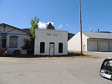
[8] In 2006, the Troy Jail and the Theodore Roosevelt Memorial Bridge were added to the National Register of Historic Places.
[4] Removal actions began in 2000, and in 2002 the site was moved to the EPA's Superfund National Priorities List.
"[4] The remaining contamination is limited to the forests and property in or near the former mine, with cleanup plans pending and with controls for higher exposures during wildfire fighting.
[17][18] An early worker described the original flora of the city site as "a carpet of velvety green grass, thickly studded with wild flowers of most every hue and color.
"[7] There are groves of ancient western red cedars nearby, some up to 12 feet (3.7 m) in diameter, which are a home for species of wildlife including pikas and flying squirrels.
[19] Troy is located in the Kootenai River Gorge, which is geologically composed of "sandstone and thin layers of shale, with folds from compression that dates back 50 to 100 million years ago.
Ancient ripple marks and large stromatolites (the remains of algae mats) are visible in the canyon.
[29] A train freight yard, a sawmill, and an ore processing facility were the main employers until they were lost to relocation and fires in the late 1920s, just before the Great Depression.
[32][33] The Theodore Roosevelt Memorial Bridge in Troy is listed on the National Register of Historic Places.
[11] Local activities include hiking, snowmobiling, camping, boating, rafting, bird watching, fishing, and geocaching.
"[40] Other nearby schools with Troy addresses include:[41] The area qualifies for in-district tuition at Flathead Valley Community College (FVCC) in Kalispell, Montana, as well as FVCC's Lincoln County Campus in Libby,[42] which has the "Glacier Bank Adult Basic Education Learning Center where students can take free classes in preparation for their GED exams.
[46] Troy is featured in Max Brooks' post-apocalyptic zombie novel World War Z as a safe zone for humanity.