Tuolumne River
Originating at over 8,000 feet (2,400 m) above sea level in Yosemite National Park, the Tuolumne drains a rugged watershed of 1,958 square miles (5,070 km2), carving a series of canyons through the western slope of the Sierra.
Prior to the arrival of Europeans, the river canyon provided an important summer hunting ground and a trade route between Native Americans in the Central Valley to the west and the Great Basin to the east.
First named in 1806 by a Spanish explorer after a nearby indigenous village, the Tuolumne was heavily prospected during the California Gold Rush in the 1850s, and the lower valley was cultivated by American settlers over the next few decades.
These projects halved the amount of water flowing from the Tuolumne into the San Joaquin, greatly reducing the once-abundant runs of salmon and steelhead in both rivers.
After briefly passing through Glen Aulin, the river enters the spectacular 20-mile (32 km) Grand Canyon of the Tuolumne, where it forms three more major waterfalls – California, LeConte and Waterwheel Falls.
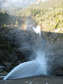
Most of the Tuolumne's main tributaries join within this reach, beginning with Cherry Creek from the north just below the intake of the Hetch Hetchy Aqueduct, which delivers water to San Francisco.
[14][15] Leaving the foothills, the Tuolumne flows approximately 50 miles (80 km) west across the Central Valley to its confluence with the San Joaquin River, passing Waterford, Hughson, Empire, Ceres and Modesto.
[2] The natural flow of the Tuolumne at the mouth is greatly reduced by diversions to both San Francisco's Hetch Hetchy municipal water system and the canals of the Modesto and Turlock irrigation districts.
From the headwaters to below Hetch Hetchy Reservoir, the river drains the Sierra highlands, which are characterized by solid, glacier-carved granitic bedrock, thin poor soils and areas of heavy forestation.
[21] Streams are generally high-gradient, clear and rocky, but large alpine meadows provide riparian and wetland habitat, which contribute sediment to the watershed's runoff.
Melting ice feeds the upper reaches of the Tuolumne River, maintaining water flow in the late summer when many other streams in the region are dry.
[24] Between Hetch Hetchy Reservoir and the upper end of Lake Don Pedro the Tuolumne flows through the Sierra foothills, where it has a lower gradient but continues to maintain a fast current.
[25] Below Don Pedro Dam the river flows across the large alluvial plain of the San Joaquin Valley, formed by millions of years of sediment deposits eroded from the Sierra.
Today farms and communities are protected by a levee system with a channel capacity of roughly 9,000 cubic feet per second (250 m3/s) at the 9th St. Bridge in Modesto – significantly smaller than the river's maximum flood potential.
Above 9500 feet, only small shrubs, flowering plants and occasional whitebark pine[58] populate the alpine zone, which is limited to the peaks around Tuolumne Meadows and along the Sierra Crest.
Native Americans set controlled fires in grassland to clear out dead foliage, providing room for new growth which in turn attracted game animals to forage.
During the 1880s American sheep ranchers brought their herds into the upper Tuolumne River watershed for summer pasture, which further damaged the range in the foothills and Sierras.
The origin of the name "Hetch Hetchy" may have been a type of edible grass that grew in the valley, which native peoples made into grain and ground in stone mortars for meal.
Many of the landscapes in the Tuolumne River area encountered by the first European explorers were thus not pristine but the result of hundreds of years of management; indeed, the famous meadows of Hetch Hetchy Valley prior to its damming only existed because of the annual burn.
[66] Another possible origin of the name Tuolumne is the Central Sierra Miwok word taawalïmi, meaning "squirrel place", referring to a Native American village on the nearby Stanislaus River.
During the latter part of that year and early 1849, mining camps were established along the Tuolumne, including Jamestown, Tuttletown, Melones, Don Pedros Bar, and Shaws Flat.
Sediment and rocks washed down by hydraulic mining and sluicing operations accumulated along the lower Tuolumne, destroying native floodplain habitat[79] and making much of the river unnavigable.
[81] As it became apparent that the Central Valley's seasonal rainfall patterns made it unsuitable for dryland farming, farmers organized to build irrigation infrastructure along the Tuolumne River.
[86] Construction on the first Don Pedro Dam began in 1921 to store floodwaters of the Tuolumne proper, allowing for the extension of the irrigation season and to provide water during dry years.
[87] A secondary purpose for the construction of the dam was that TID and MID were aware that the city of San Francisco, 160 miles (260 km) west of the river, coveted water from the Tuolumne.
After exploring fourteen sites throughout Central California, San Francisco had settled on the Tuolumne's Hetch Hetchy Valley as the ideal location to develop storage and hydroelectric power.
Signed in 1913 by President Woodrow Wilson, the Act allowed San Francisco to dam the Tuolumne River, as long as the water and power provided would be reserved exclusively for public utility, not private sale.
The irrigation dam at Don Pedro could only store enough water for a single growing season, allowing little carryover for drought years, and on the other hand providing very little flood control.
[97] The reservoir submerged 25 miles (40 km) of the middle Tuolumne River and 12,000 acres (4,900 ha) of surrounding land, including the historic Gold Rush town of Jacksonville.
"[103] The Clavey River, not being located in the national park, is open to public access, but due to its remoteness and difficulty (Class V+), and the short window of boatable spring runoff, it is only run by a handful of kayakers each year.