Tutuila
The island is attractive to tourists because of its beaches, coral reefs, and World War II relics, as well as its suitability for sporting activities such as scuba diving, snorkeling, and hiking.
According to the legend, a long time ago, an old blind woman and her granddaughter, both suffering the pangs of starvation, jumped off a cliff in the village of Vaitogi and into the roiling ocean below.
legend concerns a species of bat, known as the flying fox, which is found in a forested area of Tutuila that is part of the National Park of American Samoa.
[8] Over the centuries, the Samoans on Tutuila kept in contact with the inhabitants of the neighboring islands of Western Polynesia, Tonga, and Fiji.
Tutuila served as a place of exile for warriors and chiefs who had been defeated in the wars that ravaged much of Upolu for centuries.
In 1879, with the Samoans having declared that they were open to dealing with all three countries, the United States, Great Britain, and Germany together formed a tripartite government over the islands.
[10] In 1889, the three foreign governments held a conference in Berlin to discuss the political future of the islands and try to resolve their differences on that topic.
Naval Administration, and by the time Samuel Sailele Ripley returned home to Leone in July of that year, tensions had intensified, prompting him to align with the cause.
Led by Colonel Lester A. Dessez, they established a military base there and erected concrete bunkers along the island's coast.
Despite the island's strategic importance, it escaped almost unscathed from the war, the only exception being an attack launched from a Japanese submarine on January 11, 1942.
[10] In 1961, the US president, John F. Kennedy, appointed H. Rex Lee governor, and approved US expenditure of massive funds to develop Tutuila, which throughout the 1960s was used to finance the building of an international airport, seaport facilities, roads, schools, houses, a hospital, a tuna cannery, a modern hotel, and the installation of electricity throughout the country.
The massive US development efforts during the 1960s served to effectively solidify support for the continuation of Tutuila and the rest of American Samoa as a dependency of the United States.
Today American Samoa is an unincorporated and unorganized territory of the US, under the administration of the US Interior Department's Office of Insular Affairs.
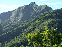
There is trail opposite to the Mount ʻAlava peak (483 km (300 mi)) which dominates the northern part of the island.
[16] Trekking along the ridge through the rain forests without any additional support system, the scenic beauty of the South Pacific Ocean provides a delightful sight.
[7] Important towns and villages now developed in the island are as follows: the Tafuna Urban area, the largest urban area in the territory, encompasses a string of villages from 'Ili'ili to Tafuna proper; Fagatago, the largest town with government offices functioning from Utulei (both are urban centers located to the northeast of Pago Pago[7]); Pago Pago (a deep harbor that divides the island into two parts[7]), the harbor town opposite to Fagatago; the Vatia village on the northern coast known for its famous beach and scenic setting, which is also a coral fringed bay; and Leone, a safe anchorage station in the past where the Europeans and Samoans first started their interaction in the early years of the island's history.
Attempts by the government to develop a larger and broader economy are restrained by Samoa's remote location, its limited transportation, and its devastating hurricanes.
It covers an area of 2,000 ha (4,900 acres)[2] 14% of the island and is bound on the north coast between Fagasa and Afono villages.
[23] The two species of flying foxes (bats) protected in the park are: Pteropus samoensis (known locally as pe'a voa) meaning "fruit bat of the forests" and Pteropus tonganus locally called pe'afaunua, which means "fruit bat of settled lands"; The roosting place of Pteropus samoensis (with prominent light colored face with brown body) is the canopy of ridge top trees, which roost alone or in small groups and are active during day time with two feeding peaks, the Pteropus tonganus (with black colored face with seal brown body) species roost in large groups (100 or more in numbers in each group) in thick forest habitat, also sometimes seen close to villages.
The descent from the peak passes through lovely vistas of the lowlands of the park and the rain forests which abound in several bird species.
Another ridge trail runs from Fagasa Pass over a length of 6.5 km (4.0 mi), goes through a very steep slope behind the rest fale (hurricane shelter), which is also negotiated through a stairway and further leads down to the serene Vatia village on the coral bay.
To monitor and give advance warning of the cyclones, several Observation stations have been established under the U.S. Federal Emergency Management Agency (FEMA), in American Samoa.
[25] According to the history of the National Oceanic and Atmospheric Administration's (NOAA) American Samoa observatory, "Hurricane Val" struck the Tutuila Island from December 7 – 10th.
The hurricane's eye passed over the southern end of the island with winds as high as 116 mi (187 km) recorded at the observatory.
In response to this disaster, National Oceanic and Atmospheric Administration (NOAA) dispatched an assessment team to survey the damage to the reefs.
The Fagalele Boys School, which was one of the oldest European style buildings built in the middle of the 19th century on the west coast of the island in Leone village, was also destroyed by Hurricane Val.
[27] At Utulei, at Blunts Point there are two guns of World War II vintage dated to 1941, which are seen in the form of two metal tubes projecting from a wall.
In addition, two more guns of identical dimensions are also seen fixed at the harbor mouth at a strategic location to create a cross fire.
Also seen are the Zion Church (1900) at Leone, the old capital of Tutuila and the monument in front of the church erected in honor of John Williams, the first missionary to visit Tutuila in 1832, the Radio Towers at Mount Olotele, the Massacre Bay in Aasu village where a monument has been installed in 1883 with stone cross to honor of the 11 French sailors only who were members of the Astrolabe and Boussole ships during the La Parouse expedition who were killed by the local Samoans in a clash on December 11, 1787; 11 Chinese and 39 Samoans also died in this conflict but are not mentioned in the honor list.