Tysons, Virginia
Dean, Inc., MicroStrategy, and Tegna Inc. As an unincorporated community, Tysons is Fairfax County's central business district and a regional commercial center.
[1] Known originally as Peach Grove, the area received the designation "Tysons Crossroads" after the Civil War.
[11] William Tyson, a Maryland native from Cecil County, purchased a tract of land from A. Lawrence Foster.
In 1962, the Fairfax County Board of Supervisors approved the Tysons Corner Shopping Center, now Tysons Corner Center, which was planned to be 88.13 acres (356,600 m2) within a 150 acres (0.61 km2) triangle bordered by Chain Bridge Road, Leesburg Pike, and the Capital Beltway.
[14] In the early 21st century, an influx of technology companies into Northern Virginia led to new office buildings and hotels to the landscape.
The rapid growth of Tysons in comparison to other locations near the Capital Beltway has been the topic of numerous studies.
[15] One factor was the aggressive promotion of Tysons by Earle Williams, for many years the CEO of the defense contracting firm Braddock Dunn & McDonald.
Existing plans call for construction of a grid layout for streets around the rail stations, projected to cost $742 million.
[19][20] Ahead of the Washington Metro Silver Line opening in mid-2014, the Fairfax County Board of Supervisors and the Tysons Partnership, a nonprofit association that represents the area's stakeholders, began rebranding the area as simply "Tysons", dropping "Corner" from the name.
Private-sector development in the United States in combination with political groups have begun the planning process behind the redevelopment of Tysons.
Edge cities such as Tysons have specific regional accessibility that has been enhanced by major projects funded by federal and state governments.
[29] Wolftrap Creek, a tributary of nearby Difficult Run, forms the community's northwestern border.
It is bordered on all sides by other Washington suburbs, including McLean to the north, Pimmit Hills to the east, Idylwood to the southeast, Dunn Loring to the south, Vienna to the southwest, and Wolf Trap to the west.
[8] Tysons's climate is characterized by hot, humid summers and generally mild to cool winters.
[30] Tysons was one of the inspirations for, and figures prominently in, Joel Garreau's pioneering study of the edge city phenomenon.
[16] As of the 2020 census (some information from the 2022 American Community Survey) there were 26,374 people, 14,222 housing units and 13,494 households residing in the CDP.
[6] Tysons is Fairfax County's central business district with the largest concentration of office space in Northern Virginia.
Dean, Inc., MicroStrategy, MITRE Corporation, SAIC, Space Adventures, Spacenet, and Sunrise Senior Living are in Tysons, though most use a McLean or Vienna address.
[40] Qatar Airways operated its North American headquarters office in Tysons,[36][41] but later moved to Washington, D.C.[42] Other firms with offices in Tysons include Adobe Systems,[43] BAE Systems Inc.,[44] Compuware,[45] Deloitte, Ernst & Young,[46] KPMG, Northrop Grumman,[47] Palantir Technologies, and Vie de France.
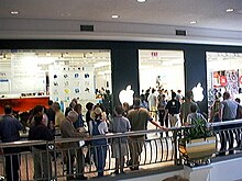
[48] The area is home to Tysons Corner Center, the largest shopping mall in the state and in the Baltimore-Washington area – and two upscale shopping centers, Tysons Galleria (also one of the largest malls in the region) and Fairfax Square, which neighbor it to the north and south respectively.
The three industries employing the largest percentages of the working civilian labor force were professional, scientific, and management, and administrative and waste management services (28.8%); educational services, health care, and social assistance (13.3%); and public administration (12.8%).
Virginia State Route 267, the east-west Dulles Toll Road, runs along the community's northern border.
[16] On July 26, 2014, the Washington Metro started offering rapid transit rail service in Tysons via its Silver Line.
[65] In February 2017, VDOT began construction on the Jones Branch Connector, a half-mile roadway that crosses Interstate 495 and connects Central and Tysons East and is projected to carry more than 32,000 vehicles per day by 2040.
This connection extended and widened existing lanes eastward along Scotts Crossing Road, ending at Route 123 adjacent to the McLean Metro Station.