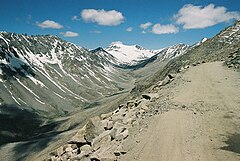
U-shaped valley
A classic glacial trough is in Glacier National Park in Montana, USA in which the St. Mary River runs.
When a U-shaped valley extends into saltwater, becoming an inlet of the sea, it is called a fjord, from the Norwegian word for these features that are common in Norway.
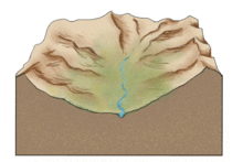
[1] Glaciers will spread out evenly in open areas, but tend to carve deep into the ground when confined to a valley.
This parabolic shape is caused by glacial erosion removing the contact surfaces with greatest resistance to flow, and the resulting section minimises friction.
The second variation is referred to as the Patagonia-Antarctica model, attributed to continental ice sheets and displaying an overall widening effect on its surroundings.
For the most part, the valley floor is wide and flat, but there are various glacial features that signify periods of ice transgression and regression.
The longitudinal profile of a U-shaped, glaciated valley is often stepwise where flat basins are interrupted by thresholds.
After deglaciation, snow and ice melt from the mountain tops can create streams and rivers in U-shaped valleys.
In volcanic mountain ranges, such as the Principal Cordillera of the Andes, glacial valley floors may be covered by thick lava flows.
These geomorphic features significantly influence sediment distribution and biological communities through their modification of current patterns.