U.S. Route 1 in Maryland
US 1 continues through the northern part of College Park as a five-lane road with center turn lane, passing through a suburban commercial area.
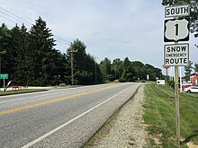
At Sunnyside Avenue, the highway reduces to a five-lane road with center turn lane and passes through a suburban commercial area in the unincorporated town of Beltsville.
US 1 gradually veers away from the railroad tracks as it approaches Laurel, passing Maryland National Memorial Park before entering a suburban commercial area ahead of Contee Road, where the center turn lane returns.
The highway continues through North Laurel, with the one-way pair coming together shortly before the intersection with Whiskey Bottom Road.
The highway passes several industrial parks, crossing Dorsey Run twice before intersecting MD 175 (Waterloo Road) in Jessup.
The undivided highway crosses over CSX Transportation's Baltimore Terminal Subdivision railroad line before reaching the partial interchange with US 1 Alt.
A short distance north of the city line, US 1 curves to the east onto Wilkens Avenue, which continues west as MD 372.
US 1 crosses Gwynns Falls and CSX Transportation's Hanover Subdivision railroad line, expanding to a divided highway before passing the Deck of Cards rowhouses[5] between Brunswick Street and Millington Avenue.
A short distance to the east, US 1 turns north onto a one-way pair, Monroe Street southbound and Fulton Avenue northbound, to pass through a densely populated urban residential area on the west side of central Baltimore.
Now a four-lane undivided road, US 1 crosses the Baltimore Terminal Subdivision again and passes Clifton Park before reaching Erdman Avenue, which heads southeast as MD 151.
North of MD 43, US 1 reduces to a four-lane undivided highway as it passes through Perry Hall, intersecting Silver Spring, Joppa, and Ebenezer roads in the midst of a commercial strip.
After the intersection with Honeygo Boulevard, US 1 descends into a steep valley to cross Gunpowder Falls, passing southeast of a park-and-ride lot before the bridge.
US 1 heads northeast into Harford County, passing through a forested area and then the residential subdivisions of Pleasant Hills before reaching MD 152 (Mountain Road).
The highway continues east through a commercial strip toward the hamlet of Benson, where US 1 converges with MD 147 (Harford Road) at an acute angle.
The old alignment of US 1, Forge Hill Road, splits to the east in Kalmia and rejoins the present highway three miles (4.8 km) later after separate crossings of Deer Creek.
US 1 intersects the northern terminus of MD 276 (Jacob Tome Memorial Highway) and crosses Stone Run twice before turning north to the Pennsylvania state line.
The original predecessors of US 1 were a collection of dirt roads cut through the forests and farmland of central and northern Maryland in the 18th century.
As a result, the Maryland General Assembly passed the first state-aid road construction law in 1904, providing matching funds from the state to the counties to surface their major highways.
By 1910, the Baltimore–Washington Boulevard was paved from the District of Columbia boundary southwest of Bladensburg north to Beltsville, with small gaps at Northeast Branch south of Hyattsville and at Paint Branch in College Park; from Contee to Elkridge; and from Hammonds Ferry Road in Halethorpe to the Baltimore city line at Gwynns Falls.
The general assembly appropriated another $120,000 (equivalent to $2.84 million in 2023[7]) in 1910 for the newly formed two year old Maryland State Roads Commission (SRC) to complete the Baltimore–Washington Boulevard.
1 was completely paved with the addition of the highway on a new alignment between Beltsville and Contee, the filling of the gaps in College Park and Hyattsville, and construction between Elkridge and Halethorpe.
The road was constructed a minimum of 14 feet (4.3 m) in width with macadam, gravel, and concrete, with curves straightened and grades reduced.
The barrage of heavy military vehicles that traveled the Baltimore–Washington Boulevard during World War I, as well as the severe winter of 1917–1918, devastated the highway.
The state road was constructed along the alignment of the turnpikes without digression except for a relocation at Gunpowder Falls to reduce the grades on the hills.
When US 1 was designated in 1927, its route through Baltimore was the same as it is today except the federal highway entered the city from the southwest along Washington Boulevard.
The final sections of the expanded highway, between the District of Columbia line and Bladensburg and a bypass to the west of Elkridge and over the upper Patapsco River, including the present underpass of the Baltimore and Ohio Railroad, were completed in 1931.
The old colonial era Main Street through Elkridge was designated as MD 477.Despite the widening of US 1 between Baltimore and Washington DC in the late 1920s, the highway continued to be a major problem for both local and through traffic.
After 1930, businesses were packed up to the edge of the four-lane, shoulder-less road that was largely built on an alignment poorly suited for the increasing speeds of vehicles.
Southwestern Boulevard was completed in 1950 as a dual highway through Arbutus, with grade separations with Sulphur Spring Road and Francis Avenue.
Despite these relocations and upgrades, true relief did not come until the first limited-access highway between Baltimore and Washington DC, the B–W Parkway, was completed in 1954 to remove long-distance traffic from US 1.