U.S. Route 2 in Michigan
Two sections of the roadway are included as part of the Great Lakes Circle Tours, and other segments are listed as state-designated Pure Michigan Byways.
One such alteration eventually created a business loop that connected across the state line with Hurley, Wisconsin, and others pushed an originally inland routing of US 2 closer to the Lake Michigan shoreline.
The roadway plays "an important role in the transportation of goods across the northern tier of states in the Midwest",[3] and is listed on the National Highway System (NHS) for its entire length.
The highway crosses the river into Gogebic County and passes a welcome center on the way into a commercial district north of downtown.
[6][8] The business route was previously a full loop that ran west through downtown Ironwood and crossed the border into Hurley and back to the main highway.
The Wisconsin Department of Transportation has removed the signage on their side of the border, which reduced the loop to a business spur that ends at the state line.
As the US Highway leaves Wakefield, it turns southeasterly through the Ottawa National Forest,[8][11] crossing Jackson Creek and two branches of the Presque Isle River.
[14] The highway travels southeasterly from Watersmeet around the many lakes and streams in the area and crosses into rural Iron County.
The roadway passes Railroad, Kennedy and Stager lakes and leaves the state of Michigan at the Brule River,[6][8] crossing into Florence County, Wisconsin for about 14 miles (23 km).
[7] US 2/US 141 re-enters Michigan where it crosses the Menominee River and subsequently meets M‑95 in Breitung Township north of Iron Mountain and Kingsford.
In downtown Iron Mountain at Ludington Street, M‑95 turns west off Stephenson Avenue to run across town to Kingsford.
The concurrent highway runs from Powers through the communities of Wilson and Spaulding on the south side of the CN Railway.
The four-lane highway crosses the Escanaba River just upstream from its mouth near the large Verso Esky Paper Mill and shifts to run immediately next to Little Bay de Noc.
In this location, US 41 separates to the north, and US 2 returns to an easterly track as a two-lane road, crossing the Rapid and Whitefish rivers and turning southeast around the head of the bay.
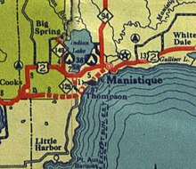
After the intersection with the northern terminus of M‑183, US 2 turns inland cutting across the base of the Garden Peninsula and enters Schoolcraft County.
Where it intersects a former routing, the main highway crosses the CN Railway one last time and runs to the south of Engadine to follow the Lake Michigan shoreline through Naubinway.
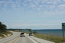
[11] The road continues along the Lake Michigan shoreline, passing Mystery Spot near Gros Cap and turning inland immediately west of St. Ignace.
A predecessor of the Great Lakes Circle Tours by seventy years, the route followed "a circular journey along the banks of lakes Michigan and Superior and Green Bay ..."[25] This route followed the modern US 2 from Ironwood to the M‑94 junction in Manistique, using the modern M‑69 and M‑95 to stay in Michigan.
Between Brevort and Moran, US 2 previously followed Worth Road inland to the Tahquamenon Trail to meet the northern extension of US 31 into the Upper Peninsula.
[45] The new highway was detoured around the Cut River Bridge until it was completed in 1946 after construction delays over steel shortages during World War II.
[50] With the coming of the Interstate Highway System in Michigan, the MSHD planned to convert the eastern section of US 2 to a freeway between St. Ignace and Sault Ste.
[18] In 2020, MDOT announced the slight relocation of US 2 in Mackinac County just west of the Cut River Bridge due to sinkholes and shoreline erosion on Lake Michigan near the roadway.
Also called Memory Lane, the group planted 140 elms and 1,840 evergreens, trees and shrubs as a landscaped parkway along 2.3 miles (3.7 km) of US 2 east of Bessemer.
This Pure Michigan Byway was designated to honor the "rich history of two industries that built a state and nation: mining and logging.
"[74] On August 26, 2007, MDOT announced that the section of US 2 that runs concurrently with M‑35 in Delta County was being included in the UP Hidden Coast Recreational Heritage Trail.
[79] In December 2012, the National Park Service approved the listing of the Upper Twin Falls Bridge that crosses the Menominee River northwest of Iron Mountain.
[83] The bridge closed to automobile traffic in September 1971,[84] and the nomination process for inclusion on the National Register of Historic Places began in 2012.
This dam would require a large section of the city to be flooded, and shallow river banks meant difficulties in any bridge construction.
Increasing traffic along Mackinac Trail prompted the MSHD to "widen its deck by five feet [1.5 m] and install new guardrails in the 1929–1930 biennium" along with the addition of decorative retaining walls.
[92] The last of the historic bridges along a former segment of US 2 is the structure carrying Ashmun Street (BS I‑75) over the Power Canal in Sault Ste.