U.S. Route 66 in Illinois
The historic Route 66, the Mother Road or Main Street of America, took long distance automobile travelers from Chicago to Southern California.
Parts of the road still carry traffic and six separate portions of the roadbed have been listed on the National Register of Historic Places.
[2][3] In Illinois and the Midwest in general, the construction of US 66 was important to the economies of small, rural towns, which saw a burst of activity when the road finally passed through.
In 1916, the Federal Aid Post Road Act, known as the Shackleford Bill, passed Congress and appropriated $75 million to be distributed to the states over the next five years.
Funding was provided on an ongoing basis, over the period of five years, and the law made the federal government an active partner in road building for the first time.
The dangers of the original pavement were recognized by the nickname "Bloody 66," which reflected the frequently deadly road accidents along the mostly rural route.
When World War II erupted, Route 66—already the heaviest trafficked highway in Illinois—saw an increase in military traffic and importance to defense strategy.
A section of IL 4 north of Auburn and south of Springfield, which was also part of the original span of US 66, was listed on the National Register of Historic Places on August 6, 1998.
Unlike other sections of Route 66 in Illinois that are listed on the National Register, the segment from Litchfield to Mount Olive does not include any contributing structures such as bridges or culverts.
This alternate alignment continued north past Waggoner, Farmersville, Divernon, Glenarm and Cotton Hill, and joined the original path in Springfield near the Old Capitol Building.
The original eastern path of US 66, most of which is currently designated as IL 53, served Gardner, Braceville, Godley, and Braidwood before entering Wilmington.
The three-span, continuous steel multibeam bridge, in the northbound lanes, dates to 1950 and features concrete balusters and top rails.
The later alignments rejoin this original path at Welco Corners, an early crossroads now part of Bolingbrook that by the 1920s had added a truck stop and other motorists' services.
Although the shop closed and the last soft serve ice cream was sold in the early 1950s, the building was designated a local landmark in November 2010.
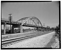
Between Gardner and Braceville, a magnificent through-arch bridge carried this alignment of Route 66 over railroad tracks; unfortunately it deteriorated beyond repair and was demolished in 2000.
Most portions of the 1940 western alignment that were not incorporated into the new freeway reverted to their previous state routes, except for the section from Gardner through Braidwood, which became IL 129.
Between 2007 and 2008, the section of I-55 between I-80 and Welco Corners, originally built as the redirected path of US 66 in 1957, was rebuilt and widened to three lanes in each direction to accommodate modern traffic loads.
The stretch from Darien northeast through what is now Countryside and Hodgkins was then part of a large rural farmland collectively known as Lyonsville, as the eastern end of it was located in Lyons Township in Cook County.
A mile or so further east near the IL 83 interchange, Dell Rhea's Chicken Basket in Willowbrook is still a popular stop for motorists on the route, although being cut off from the Interstate did cost it a significant amount of business after I-55 was built and during the 1960s through 1980s.
[21] Distances listed are based on entering Illinois via the Veterans Memorial Bridge and following an alignment through Plainfield, using the last known non-freeway route where drivable.
[23] The earliest gas stations were curbside but these were quickly rendered obsolete because of their tendency to back up traffic when a customer used the roadside pumps.
[23] Examples of extant filling stations along Route 66 in Illinois can be found in varying states of disrepair, and a few have been fully restored.
Constrained by tight finances and a mistrust of the unknown quality of road food, these earliest travelers were often reluctant to eat out.
[25] Large companies, such as Johnson's, or the Steak 'n Shake chain which began in Normal and was based on the pioneering idea of curbside service at the car, enjoyed success alongside what were mostly "mom-and pop" eateries dotting the Mother Road.
[31] The Ariston is an excellent example of the type of mom and pop operation that flourished along Route 66 in Illinois, as is the Palms Grill Café in Atlanta.
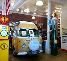
[36] Vehicles used by late Route 66 travelling artist Bob Waldmire, including a Volkswagen Type 2 minibus that inspired the creation of Pixar animated character Fillmore in the film Cars, are part of the museum collection in Pontiac.
[39] Route 66 in Illinois is also famous for some very quirky jumbo-size attractions, such as the former Bunyon's Paul Bunyan statue, a 19-foot (5.8 m) "Muffler Man" giant originally from a Berwyn hot dog shack that now stands in the quaint downstate community of Atlanta; the similar Gemini Giant in Wilmington; the largest wind farm East of the Mississippi River, Twin Groves Wind Farm, just east of Bloomington, with more than 240 turbines across 22,000 acres (8,900 ha); the Railsplitter Covered Wagon in Lincoln, the world's largest according to Guinness Book of World Records; the Route 66 mural in Pontiac that depicts the world's largest US 66 shield; and the Tall Bunny at Henry's Ra66it Ranch in Staunton.
[40] There are a number of other attractions along Historic US 66 that are in the process of being restored, such as Sprague's Super Service gas station in Normal[41] and The Mill on 66 restaurant in Lincoln.
[50] This section of Route 66 also offers two other interesting side trips: Illinois Amish Country[51] and the Shelbyville State Fish and Wildlife Area.
[53] Looking at the historic roadway through Illinois from a different perspective, it reveals a unique history that tells the story of movement and road building across the prairie.