U.S. Route 101
The highway crosses over the Columbia River on the Astoria–Megler Bridge into Washington, where it follows Willapa Bay and an inland route to Aberdeen and Olympic National Park.
The highway is a major north–south link along the Pacific coast north of San Francisco but does not serve the largest cities in Oregon and Washington; that role is instead filled by I-5, which has a more direct inland routing.
US 101 was established in 1926 and followed several historic routes, including El Camino Real, which linked California's early Spanish missions, pueblos, and presidios.
Later projects expanded the Bayshore Freeway in the San Francisco Bay Area and relocated sections of the highway in Oregon in response to landslides and erosion.
[16][17] Its southern terminus is in Boyle Heights at the 135-acre (55 ha) East Los Angeles Interchange, one of the busiest freeway junctions in the United States, where US 101 meets I-5, I-10, and SR 60.
[11] The Santa Ana Freeway continues across Downtown Los Angeles and passes Union Station, a major transit hub, and government buildings before it reaches a junction with SR 110.
[21] The highway crosses the Santa Lucia Range through Cuesta Pass and follows the Salinas River northwest through Atascadero and the wine-growing region surrounding Paso Robles.
[21] Beyond the San Francisco Bay Area, US 101 is primarily an undivided highway with some short freeway sections and serves as the primary route in the rugged North Coast region.
[45] The highway remains elevated from the coastline and briefly descends to sea level near the Pistol River State Scenic Viewpoint before climbing Cape Sebastian on its way to Gold Beach.
[47] US 101 returns to the coastline near the Heceta Head Lighthouse and continues north along several high cliffs around Cape Perpetua and Yachats that overlook the beaches.
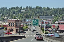
[59] The highway travels around the community of Cannon Beach, home to the landmark Haystack Rock,[54][60] and turns northeast to bypass Tillamook Head and intersect US 26—a major route to Portland.
The highway traverses Fort Columbia State Park in a tunnel and passes through Chinook on the north side of the river's mouth towards Ilwaco, near Cape Disappointment.
[62] From Ilwaco, US 101 briefly travels north before turning east at Seaview, the southernmost city on the Long Beach Peninsula,[63] and following Willapa Bay to a junction with State Route 4 (SR 4) on the Naselle River.
[64] The highway continues along the east side of the bay through South Bend to Raymond, where it travels inland to cross the forested Willapa Hills to reach Aberdeen.
[66][68] The highway turns west from Lake Quinault to reach the Pacific coastline, which it follows for 15 miles (24 km) between Queets and Ruby Beach within Olympic National Park.
[72] The highway enters Port Angeles and uses city streets to reach the northernmost point of US 101,[67][70] near the ferry terminal for the Black Ball Line to Victoria, British Columbia.
[65] The four-lane highway turns east to follow the Strait of Juan de Fuca through a rural prairie and becomes a super two expressway as it bypasses Sequim.
[65] The highway travels south and crosses a pass in the Olympic Mountains near Mount Walker before it reaches the west shore of Hood Canal, which it follows for more than 50 miles (80 km).
[75] The freeway merges with SR 8 and continues southeast to reach its northern terminus at I-5 in Tumwater,[5] near the Washington State Capitol campus in nearby Olympia.
[99][100] The project paved several existing sections of the state roads and also constructed 7 miles (11 km) of new highway from the Queets River to Ruby Beach near Kalaloch.
[101] The Washington State Highway Commission submitted an application to AASHO in 1955 to extend US 101 northeast from Discovery Bay to Whidbey Island and Mount Vernon, where it would terminate at US 99.
[114][115] El Camino Real was re-designated as US 101 Alternate in 1936,[116] which sparked outcry from businesses and groups who lobbied for a reversal of the change that was submitted by state officials to AASHO.
[119][120] In the late 1940s, the California state government announced plans to convert most of US 101 between Los Angeles and San Francisco to freeways using funds from the Collier–Burns Highway Act of 1947.
[121][122] Prior to the act, the Cahuenga Pass Freeway had opened in June 1940 between Hollywood and the San Fernando Valley in Los Angeles to replace a narrow, winding mountain road.
[124] The San Diego–San Francisco section of US 101 was designated as El Camino Real by the California state government in 1959 as part of a program to add historic markers on the highway.
[141][142] Plans to extend the Central Freeway and other thoroughfares through San Francisco to the Golden Gate Bridge were later cancelled by the mid-1960s following widespread opposition and protests from city residents.
[145] A 53-mile (85 km) realignment from Brookings to Gold Beach and a more direct route from Bandon to Coos Bay to bypass Coquille were completed as part of this program in the early 1960s.
[154] The final traffic signal on the 435-mile (700 km) section of US 101 between Los Angeles and San Francisco, located at Anacapa Street in Santa Barbara, was removed in November 1991.
[156] The Central Freeway's northernmost leg in San Francisco was demolished in the early 2000s after it had sustained damage in the 1989 Loma Prieta earthquake, which required the upper deck to be removed in 1997.
[168] Other portions of the highway in southwestern Oregon had landslide and subsidence issues, including a section in Harbor that was closed for several weeks in early 2016 by a 80-foot (24 m) sinkhole.