Ugljevik
The municipality is located in the countryside of the eastern foothills of Mount Majevica, where the mountains start descending towards the flatlands of Semberija, to which it is tied to more than any other surrounding area.
Exploration indicates huge[clarification needed] reserves of quality coal, with seams stretching in every direction, even reaching Zvornik on the Drina river.
These include five locations with groupings of medieval stone sarcophagi, called stećci, and three dating from the Roman period.
The first population census of the region showed five settlements with a total of 55 houses, which date from prior to arrival of the Ottoman Turks in the 15th century.
During troubled times the population would leave these parts with most of the succeeding population—the forebears of the present Majevicans—coming from Eastern and ‘Old’ Herzegovina in the 19th century.
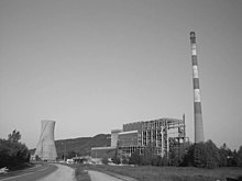
During the past hundred years, the pace and extent of development of the Ugljevik region has been determined by coal production.
The coal from Bogutovo Selo surface mine has a calorific value of 2,550 kcal/kg (10.68 MJ/kg), and it is estimated that the reserves are sufficient to satisfy the needs of four 300 megawatt coal-fired power plants.
In relation to this, the IFOR info magazine “Talon” wrote in one of its articles “Cold War melted on the Balkan sun”.
This, coupled with other circumstances —primarily the fine infrastructure, employment opportunities, healthy environment and proximity to populous towns — contribute to the municipality developing quickly and the residents choice to remain in them.
Mosques are also being rebuilt, after the war, in the villages of Janjari, Atmačići, Glinje and Srednja Trnova Education has a long tradition in the municipality of Ugljevik.
School buildings are modern and well equipped, with an adequate number of teachers ensuring a high standard of education.
It had once reached New Ugljevik, its waves cutting into the mountainside above the school complex where fossilised traces of aquatic flora and fauna are visible.
From its cliffs, reaching up to 451 metres (1,480 feet) above sea level, the flatlands of Semberija can be seen, while beyond, across the Drina, are discernible Mačva and Mount Cer.
The following table gives a preview of total number of registered people employed in professional fields per their core activity (as of 2018):[1] Sports and fitness culture are on the rise in Ugljevik.
The pride of these areas is the Football Club Rudar, which has won the most important trophies and titles in Republika Srpska and spread the name of Ugljevik throughout the Republic.
Initially beginning with county and regional competitions, it has progressed to the world karate scene, which has been extremely high-quality in recent years.
There are additionally nine soccer clubs in the various villages: Partizan in Donja Trnova, Mladost in Bogutovo Selo, Budućnost in Ravno Polje, Strijelac in Tutnjevac, Proleter in Ugljevik Selo, Borac in Ugljevička Obrijez, Majevica in Donja Zabrfmđe, Hajduk in Mezgraja and Graničar in Korenita.
Ugljevik is twinned with:[2] Una-Sana Central Bosnia Posavina Herzegovina-Neretva Tuzla West Herzegovina Zenica-Doboj Sarajevo Bosnian Podrinje Canton 10