Ukkusiksalik National Park
There is, however, a remarkable quantity of stone relics, mainly tent rings from Thule people, inuksuit, caches, and shelters which provide evidence that the coast of Wager Bay has been inhabited for thousands of years.
In the 1860s, American explorer Charles Francis Hall's two-masted ship Monticello reached Roes Welcome Sound in 1864 while searching for John Franklin's lost Northwest Passage expedition of 1845 and had to overwinter at the mouth of Wager Bay.
In 1879, another American expedition led by Lieutenant Frederick Schwatka searching for John Franklin passed nearby Wager Bay by land.
At the beginning of the 20th century, the Canadian government showed an interest in the Wager Bay region and sent geologist Albert Peter Low on Neptune in order to establish Canada's sovereignty over the Arctic north.
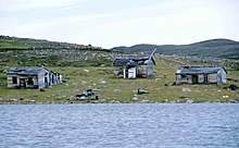
At nearly the same time, in 1900, the American whaler George G. Cleveland, working alone, established a whaling station near the entrance of the bay, that operated for the next four years.
Situated at a favorable location at the northern end of Roes Welcome Sound, this post became important for the company's intention to expand their business towards the north.
Alongside these local activities, the Hudson's Bay Company, during the first years of the 20th century, made a great effort to get the fur trade under control.
They started to build up a large and dense network of posts from the barren lands of northwest Hudson Bay to the northern coast of the continent.
That new post was meant to include the Ukkusiksalingmiut area to the Back River estuary, 250 km (160 mi) to the northwest, into the company's strategy, thereby, if ever possible, preventing commercial activities of competitors, Revillon Frères, operating from their Baker Lake base.
At Hudson Bay's northwest corner, some 200 km (120 mi) northeast of Chesterfield Inlet, near the Capes Fullerton and Kendall, is the entrance of Roes Welcome Sound, which extends northwards between the Barrenlands of the Kivalliq Region (meaning: border of the land) and Southampton Island to Repulse Bay, where there is a settlement of that name, situated at the Arctic circle.
The tides rise and fall up to 8 metres (26 ft) and currents are extraordinary and cause large accumulations of ice masses during most of the year, often preventing the passage of watercraft.
During early summer the rising flood water washes large quantities of drifting ice and icebergs into the bay.
Even at its western end, tides are impressive, between Wager Bay and the 2 km (1.2 mi) wide Ford Lake (Tusjujak in Inuktitut), so-called Reversing Falls occur.
A remarkable feature is that at the south shore of Wager Bay a steep mountain range, gorged by former glaciers, strongly influences the weather.
Due to its proximity to Hudson Bay, drops in temperature and strong fog are normal during summertime, as blizzards are during early autumn.
Peary caribou (Rangifer tarandus) and curious Arctic ground squirrels (Spermophilus parryii) come close to Sila Lodge.
The place can be reached by a hired plane – usually one would depart from Baker Lake, about 350 km (220 mi) away, where scheduled flights arrive from Rankin Inlet.
One can also approach by motorboat from Repulse Bay, where Parks Canada runs a station, but due to possible problems with ice this might take longer and therefore will only be considered by explorers or movie teams who have to bring a lot of equipment.
From Sila Lodge, guided tours were offered, for instance boating tours to the Wager Bay islands, or to Ford Lake across the reversing falls, to the former Hudson's Bay Company outpost, or walks to the surrounding area, where one would find impressive relics of earlier settlements, such as tent rings, qarmaq and inuksuk.